Chipman | |
|---|---|
| Village of Chipman | |
 Nativity of the Mother of God (St. Mary's) Ukrainian Catholic Church | |
| Nickname: Coyote Country | |
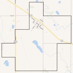
 Boundaries of Chipman | |
Location in Alberta | |
| Coordinates: 53°41′56.6″N 112°38′08.7″W / 53.699056°N 112.635750°W | |
| Country | Canada |
| Province | Alberta |
| Planning region | North Saskatchewan |
| Municipal district | Lamont |
| Incorporated[1] | |
| • Village | October 21, 1913 |
| Government | |
| • Mayor | Morris Langevin |
| • Governing body | Chipman Village Council |
| Area (2021)[2] | |
| • Land | 9.6 km2 (3.7 sq mi) |
| Elevation | 670 m (2,200 ft) |
| Population (2021)[2] | |
• Total | 246 |
| • Density | 25.6/km2 (66/sq mi) |
| Time zone | UTC−7 (MST) |
| • Summer (DST) | UTC−6 (MDT) |
| Highways | Highway 15 Highway 834 |
| Website | www |
Chipman is a village in central Alberta, Canada within Lamont County and Census Division No. 10. It is located on Highway 15, approximately 11 km (7 mi) southeast of Lamont, 22 km (14 mi) northwest of Mundare, 70 km (44 mi) east of Edmonton, and 30 km (18 mi) northeast of the Yellowhead Highway entrance to Elk Island National Park.
- ^ "Location and History Profile: Village of Chipman" (PDF). Alberta Municipal Affairs. October 14, 2016. p. 162. Retrieved October 17, 2016.
- ^ a b Cite error: The named reference
2021censuswas invoked but never defined (see the help page).
