Chitina
Tsedi Na' | |
|---|---|
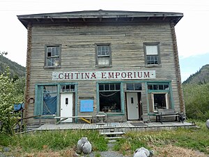
 Chitina Emporium in 2011 | |
 Location of Chitina, Alaska | |
| Coordinates: 61°30′57″N 144°26′12″W / 61.51583°N 144.43667°W | |
| Country | United States |
| State | Alaska |
| Census Area | Copper River |
| Government | |
| • State senator | Click Bishop (R) |
| • State rep. | Mike Cronk (R) |
| Area | |
• Total | 99.49 sq mi (257.67 km2) |
| • Land | 84.68 sq mi (219.31 km2) |
| • Water | 14.81 sq mi (38.35 km2) |
| Population (2020) | |
• Total | 101 |
| • Density | 1.19/sq mi (0.46/km2) |
| Time zone | UTC-9 (Alaska (AKST)) |
| • Summer (DST) | UTC-8 (AKDT) |
| ZIP code | 99566 |
| Area code | 907 |
| FIPS code | 02-14110 |
Chitina (Ahtna Athabascan Tsedi Na' [tʃɛ.diː.näʔ] < tsedi "copper" + na' "river")[2] is a census-designated place (CDP) in Copper River Census Area, Alaska, United States. At the 2010 census the population was 126, up from 123 in 2000.
- ^ "2020 U.S. Gazetteer Files". United States Census Bureau. Retrieved October 29, 2021.
- ^ Smelcer, John (2011). AHTNA NOUN DICTIONARY and Pronunciation Guide (2nd Edition) (PDF). Copper Center, Alaska: The Ahtna Heritage Foundation. pp. 28, 53 108. ISBN 0-9656310-2-8. Archived from the original (PDF) on December 14, 2014. Retrieved December 13, 2014.