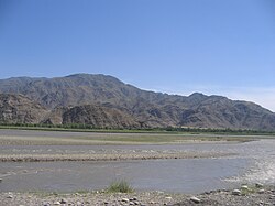
| Chitral River Kunar | |
|---|---|
 | |
 Course of the Chitral River | |
| Location | |
| Countries | Pakistan and Afghanistan |
| Provinces | Khyber Pakhtunkhwa (Pakistan) (Afghanistan) |
| Physical characteristics | |
| Source | Hindu Kush Mountains in Chitral |
| Mouth | Kabul River |
• location | Jalalabad |
| Length | 480 km (300 mi) |
| Basin size | 26,000 km2 (10,000 sq mi) |
| Basin features | |
| Tributaries | |
| • left | Shishi River |
| • right | Lotkoh River, Landai Sin River, Pech River |
The Chitral River,[a] also known in Afghanistan as the Kunar River,[b] is a 480 kilometres (300 mi) long river in northern Pakistan and eastern Afghanistan. It originates from the Chiantar glacier, located at the border of Gilgit Baltistan and Chitral which falls within the Khyber Pakhtunkhwa province of Pakistan. At Arandu it enters into Afghanistan, where it is named as the Kunar River.[1] It later merges with Kabul river in the Nangahar Province of Afghanistan. The river system is fed by melting glaciers and snow of the Hindu Kush mountains. The Chitral River serves as a major a tributary of the Kabul river, which is in turn a tributary of the Indus River.[2]
Cite error: There are <ref group=lower-alpha> tags or {{efn}} templates on this page, but the references will not show without a {{reflist|group=lower-alpha}} template or {{notelist}} template (see the help page).
- ^ Nibanupudi, Hari Krishna; Shaw, Rajib (2014). Mountain Hazards and Disaster Risk Reduction. Japan: Springer. p. 37. ISBN 978-4-431-55242-0.
- ^ The Afghan War, 1838-1842: From the Journal and Correspondence of the Late Major-General Augustus Abbott, editor Charles Rathbone Low, publisher R. Bentley & Son, 1879, Google Books