7°00′01″S 156°57′50″E / 7.00028°S 156.96389°E
Choiseul Province
Soesol Provins (Pijin) | |
|---|---|
 | |
| Coordinates: 7°0′1″S 156°57′50″E / 7.00028°S 156.96389°E | |
| Country | |
| Capital | Taro Island |
| Government | |
| • Premier | Hon. Harrison Benjamin |
| Area | |
| • Total | 3,837 km2 (1,481 sq mi) |
| Population (2020) | |
| • Total | 36,719 |
| • Density | 5.2/km2 (13/sq mi) |
| Time zone | UTC+11 (+11) |

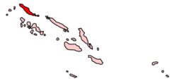
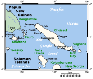
Choiseul Province is one of the nine provinces of Solomon Islands. It lies southeast of Bougainville (part of Papua New Guinea), west of Santa Isabel Island, and north of Vella Lavella, Kolombangara & New Georgia. It has a population of 36,719 (as of 2020) [1]
The province has three major islands: Choiseul, Wagina, and Rob Roy. Choiseul Island (commonly known as Lauru to the natives) has a land area of 3,294 square kilometres (1,272 sq mi); Wagina's is 243 square kilometres (94 sq mi); Rob Roy's is 200 square kilometres (77 sq mi). Taro Island, the capital of the province, has an area of 1.5 square kilometres (0.58 sq mi).
- ^ "Choiseul - Ministry of Provincial Government and Institutional Strengthening, Solomon Islands". www.mpgis.gov.sb. Retrieved 22 July 2023.
