This article needs additional citations for verification. (February 2022) |
Chongpyong County
정평군 | |
|---|---|
| Korean transcription(s) | |
| • Chosŏn'gŭl | 정평군 |
| • Hancha | 定平郡 |
| • McCune-Reischauer | Chŏngp'yŏng kun |
| • Revised Romanization | Jeongpyeong-gun |
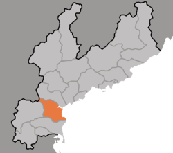
 Map of South Hamgyong showing the location of Chongpyong | |
| Coordinates: 39°47′14.3″N 127°23′43.4″E / 39.787306°N 127.395389°E | |
| Country | North Korea |
| Province | South Hamgyong Province |
| Administrative divisions | 1 ŭp, 2 workers' district, 42 ri |
| Area | |
| • Total | 747 km2 (288 sq mi) |
| Population (2008[1]) | |
| • Total | 179,114 |
Chŏngp'yŏng County is a county in South Hamgyŏng province, North Korea. It borders South P'yŏngan province to the south, and the East Korea Bay to the east.