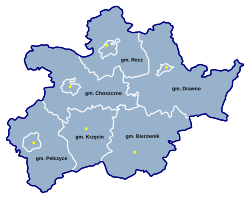
Choszczno County
Powiat choszczeński | |
|---|---|
 Location within the voivodeship | |
 Division into gminas | |
| Coordinates (Choszczno): 53°10′N 15°24′E / 53.167°N 15.400°E | |
| Country | |
| Voivodeship | West Pomeranian |
| Seat | Choszczno |
| Gminas | |
| Area | |
• Total | 1,327.95 km2 (512.72 sq mi) |
| Population (2006) | |
• Total | 50,066 |
| • Density | 38/km2 (98/sq mi) |
| • Urban | 23,845 |
| • Rural | 26,221 |
| Car plates | ZCH |
| Website | http://www.powiatchoszczno.pl |
Choszczno County (Polish: powiat choszczeński) is a unit of territorial administration and local government (powiat) in West Pomeranian Voivodeship, north-western Poland. It came into being on January 1, 1999, as a result of the Polish local government reforms passed in 1998. Its administrative seat and largest town is Choszczno, which lies 62 kilometres (39 mi) south-east of the regional capital Szczecin. The county contains three other towns: Recz, 15 km (9 mi) north-east of Choszczno, Pełczyce, 16 km (10 mi) south-west of Choszczno, and Drawno, 24 km (15 mi) east of Choszczno.
The county covers an area of 1,327.95 square kilometres (512.7 sq mi). As of 2006 its total population is 50,066, out of which the population of Choszczno is 15,753, that of Recz is 2,995, that of Pełczyce is 2,698, that of Drawno is 2,399, and the rural population is 26,221.
The county includes the lake districts of Pojezierze Choszczeńskie, Pojezierze Myśliborskie, Pojezierze Ińskie and Równina Drawska. Within Gmina Drawno is a large forest (Puszcza Drawska) which is part of the Drawno National Park.

