| Chulyshman | |
|---|---|
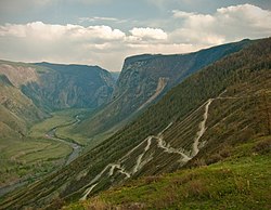
 View from Katu-Yaryk pass | |
 | |
| Physical characteristics | |
| Source | Lake Dzhulukul |
| • coordinates | 50°13′15″N 89°38′09″E / 50.22083°N 89.63583°E |
| • elevation | 2,200 m (7,200 ft) |
| Mouth | Lake Teletskoye |
• coordinates | 51°21′N 87°46′E / 51.350°N 87.767°E |
| Length | 241 km (150 mi) |
| Basin size | 16,800 km2 (6,500 sq mi) |
| Basin features | |
| Progression | Lake Teletskoye→ Biya→ Ob→ Kara Sea |
The Chulyshman (Russian: Чулышман; Altay: Чолышман, Çolışman) is a river in Altai Republic in Russia. The river is 241 kilometres (150 mi) long, and its drainage basin covers 16,800 square kilometres (6,500 sq mi).[1] The Chulyshman flows into Lake Teletskoye. It freezes up during late October through early December and stays icebound until late March through early May. Its main tributary is the Bashkaus.
- ^ "Река Чулышман in the State Water Register of Russia". textual.ru (in Russian).