This article needs additional citations for verification. (June 2018) |
| Circuito Norte (CN) | |
|---|---|
| Northern Circuit | |
| I–3 | |
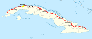
 Map of the CN highlighting, in dark red, the motorways "Vía Blanca" and "Panamericana", both part of its route | |
 The CN across the municipality of Bolivia | |
| Route information | |
| Length | 1,222 km (759 mi) |
| Major junctions | |
| West end | |
I–3 Autopista Sur (Varadero) Cayo Santa María Causeway | |
| East end | |
| Location | |
| Country | Cuba |
| Major cities | Mantua, Mariel, Havana, Santa Cruz del Norte, Matanzas, Varadero, Cárdenas, Sagua la Grande, Remedios, Caibarién, Yaguajay, Morón, Nuevitas, Puerto Padre, Holguín, Mayarí, Sagua de Tánamo, Moa, Baracoa |
| Highway system | |


The Circuito Norte (CN), meaning "Northern Circuit", is a west-east highway spanning the length of the island of Cuba, through the Atlantic Coast. With a length of 1,222 km, it is the second-longest Cuban highway, after the "Carretera Central"; and two sections of it, named "Vía Blanca" and "Panamericana", are classified as Expressways.[1]
- ^ Source: Mapa de Carreteras de Cuba (Road map of Cuba). Ediciones GEO, Havana 2011 - ISBN 959-7049-21-X
