City of Carlisle | |
|---|---|
Former non-metropolitan district and city | |
 Carlisle Civic Centre in Rickergate | |
|
| |
| Motto(s): "Be Just and Fear Not" | |
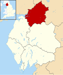
 Carlisle shown within Cumbria | |
| Coordinates: 54°53′27″N 2°56′38″W / 54.89083°N 2.94389°W | |
| Sovereign state | |
| Country | |
| Ceremonial county | Cumbria |
| Historic county | Cumberland |
| Admin HQ | Carlisle |
| Founded | 1 April 1974 |
| Abolished | 31 March 2023 |
| Government | |
| • Type | City |
| • Governing body | Carlisle City Council |
| Area | |
• Total | 1,039.97 km2 (401.53 sq mi) |
| Population (2021) | |
• Total | 110,255 |
| • Density | 110/km2 (270/sq mi) |
| • Ethnicity | 97.6% White 0.9% South Asian 0.6% Mixed 0.2% Black 0.5% Chinese or Other |
| Time zone | UTC+0 (Greenwich Mean Time) |
| Postcode | |
| ONS code | 16UD (ONS) E07000028 (GSS) |
| OS grid reference | NY394555 |
| Website | www.carlisle.gov.uk |
 | |
| Click the map for an interactive fullscreen view | |
The City of Carlisle (/kɑːrˈlaɪl/ kar-LYLE, locally /ˈkɑːrlaɪl/ KAR-lyle[1]) was a local government district of Cumbria, England, with the status of a city. It was named after its largest settlement, Carlisle, but covered a far larger area which included the towns of Brampton and Longtown, as well as outlying villages including Dalston, Scotby and Wetheral. In 2011 the district had a population of 107,524,[2] and an area of 1,039.97 square kilometres (402 sq mi).[3]
The district boundaries were set as part of the provisions of the Local Government Act 1972, and covered an amalgamation of two former local government districts, the City and County Borough of Carlisle and the Border Rural District of Cumberland.[4] The district shared a border with Scotland (to the north), and was bounded on the southwest by the borough of Allerdale, and on the south by the district of Eden. The county of Northumberland was to the east.
Although the district boundaries dated to the 20th century, the city traces its origins to a 1st-century Roman outpost associated with Hadrian's Wall. The Brythonic settlement that expanded from this outpost was destroyed by the Danes in 875. Thereafter the region formed part of the Southern Uplands of Scotland, until colonised under King William II of England in 1092. William II built Carlisle Castle, which houses a military museum. Carlisle Cathedral, founded in the 12th century, is one of the smallest in England.
A border city, and the third most northerly city in England, Carlisle district predominantly spanned the flood plain of the River Eden. Commercially, it was linked to the rest of England via the M6 motorway, and to the Scottish Lowlands via the A74(M) and M74 motorways.
In July 2021 the Ministry of Housing, Communities and Local Government announced that in April 2023, Cumbria would be reorganised into two unitary authorities.[5] On 1 April 2023, Carlisle City Council was abolished and its functions transferred to the new unitary authority of Cumberland, which also incorporates the former districts of Allerdale and Copeland.[6]
From 1 April 2023 the "City of Carlisle" was redefined to cover the following wards: Belah and Kingmoor, Botcherby and Harraby North, Cathedral and Castle, Currock and Upperby, Denton Holme and Morton South, Harraby South and Parklands, Newtown and Morton North, Sandsfield and Morton West and Stanwix and Houghton.
Charter Trustees were formed from the councillors that cover the said areas; they act as appropriate bodies in which historic rights and privileges of Carlisle, including the Mayoralty will continue until a governance review will determine the need of a Town Council.[citation needed]
- ^ Roach, Peter; Hartman, James; Setter, Jane; Jones, Daniel, eds. (2006), Cambridge English Pronouncing Dictionary (17th ed.), Cambridge: CUP, ISBN 978-0-521-68086-8
- ^ UK Census (2011). "Local Area Report – Carlisle Local Authority (E07000028)". Nomis. Office for National Statistics. Retrieved 27 March 2021.
- ^ "Archived copy" (PDF). Archived from the original (PDF) on 7 October 2011. Retrieved 1 February 2010.
{{cite web}}: CS1 maint: archived copy as title (link) Cumbria County Council Census key statistics summary - ^ Carlisle City Council (20 May 2009), Council Constitution and Financial Procedure Rules (PDF), Carlisle City Council, retrieved 22 June 2009[dead link]
- ^ "Next steps for new unitary councils in Cumbria, North Yorkshire and Somerset". GOV.UK. Retrieved 1 January 2022.
- ^ "Local Government Reorganisation. Delivering Two New Councils for Cumbria". Archived from the original on 1 April 2023. Retrieved 1 January 2022.

