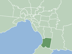
| City of Frankston Victoria | |||||||||||||||
|---|---|---|---|---|---|---|---|---|---|---|---|---|---|---|---|
 | |||||||||||||||
 | |||||||||||||||
| Population | 139,281 (2021)[1] | ||||||||||||||
| • Density | 1,070/km2 (2,770/sq mi) | ||||||||||||||
| Established | 1994 1860 (original) | ||||||||||||||
| Area | 130 km2 (50.2 sq mi)[1] | ||||||||||||||
| Mayor | Kris Bolam JP | ||||||||||||||
| Council seat | Frankston | ||||||||||||||
| Region | Greater Melbourne | ||||||||||||||
| State electorate(s) | |||||||||||||||
| Federal division(s) | Dunkley | ||||||||||||||
 | |||||||||||||||
| Website | City of Frankston | ||||||||||||||
| |||||||||||||||
The City of Frankston (officially known as Frankston City Council) is a local government area (LGA) in Victoria, Australia in the southern suburbs of Melbourne. It has an area of 130 square kilometres, and in June 2018, the City of Frankston recorded a population of 141,845.[1]
Despite its similar area and name, the City of Frankston is a different entity to the former City of Frankston which existed from 1966 until 1994, which was a continuation of the former Shire of Frankston and was abolished under state government reforms. This is similar to the situation for the Shire of South Gippsland and Shire of Glenelg, but is unlike the City of Melbourne, City of Knox, City of Whittlesea and City of Melton, whose administrations stayed intact through the amalgamations of the early 1990s.[citation needed]
- ^ a b c "3218.0 – Regional Population Growth, Australia, 2017-18: Population Estimates by Local Government Area (ASGS 2018), 2017 to 2018". Australian Bureau of Statistics. 27 March 2019. Retrieved 25 October 2019. Estimated resident population, 30 June 2018.