| City of Kingston Victoria | |||||||||||||||
|---|---|---|---|---|---|---|---|---|---|---|---|---|---|---|---|
 | |||||||||||||||
 | |||||||||||||||
| Population | 163,431 (2018)[1] (44th) | ||||||||||||||
| • Density | 1,796/km2 (4,651/sq mi) | ||||||||||||||
| Established | 1994 | ||||||||||||||
| Area | 91 km2 (35.1 sq mi)[1] | ||||||||||||||
| Mayor | Jenna Davey-Burns (2023-24) [2] | ||||||||||||||
| Location | 15 km (9 mi) from Melbourne city centre | ||||||||||||||
| Council seat | Cheltenham | ||||||||||||||
| Region | Greater Melbourne | ||||||||||||||
| State electorate(s) | |||||||||||||||
| Federal division(s) | |||||||||||||||
 | |||||||||||||||
| Website | City of Kingston | ||||||||||||||
| |||||||||||||||
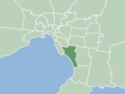
The City of Kingston is a local government area in Victoria, Australia in the south-eastern suburbs of Melbourne, its northern boundary lying approximately 15 km from the Melbourne city centre[3] along the north-eastern shorelines of Port Phillip. It covers an area of 91 km² and has an estimated population of 163,431 people.[1][3]
- ^ a b c "3218.0 – Regional Population Growth, Australia, 2017–18: Population Estimates by Local Government Area (ASGS 2018), 2017 to 2018". Australian Bureau of Statistics. Australian Bureau of Statistics. 27 March 2019. Retrieved 25 October 2019. Estimated resident population, 30 June 2018.
- ^ "Cr Jenna Davey-Burns".
- ^ a b "Kingston City Council – Local Government Victoria – Department for Victorian Communities". Find your local council. Department for Victorian Communities. 24 January 2007. Archived from the original on 3 September 2007. Retrieved 20 July 2007.