City of Milton Keynes | |
|---|---|
| Motto(s): By knowledge, design and understanding | |
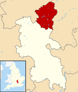
 City of Milton Keynes, shown within Buckinghamshire and England | |
| Coordinates: 52°07′N 0°46′W / 52.117°N 0.767°W | |
| Sovereign state | United Kingdom |
| Constituent country | England |
| Region | South East |
| Ceremonial county | Buckinghamshire |
| Incorporated | 1 April 1974 |
| Government | |
| • Type | Unitary authority |
| • Governing body | Milton Keynes City Council |
| • MPs | Chris Curtis (Lab) (Milton Keynes North) Emily Darlington (Lab) (Milton Keynes Central) Callum Anderson (Lab) Buckingham and Bletchley |
| Area | |
| • Total | 119 sq mi (309 km2) |
| Population (2022)[2] | |
| • Total | 292,180 |
| • Rank | 52nd |
| • Density | 2,450/sq mi (947/km2) |
| Postcode | |
| Area code | 01908 |
| ISO 3166 code | GB-MIK |
| GSS code | E06000042 |
| Website | milton-keynes |
The City of Milton Keynes is a unitary authority area with both borough and city status, in Buckinghamshire.[3] It is the northernmost district of the South East England Region. The borough abuts Bedfordshire, Northamptonshire and the remainder of Buckinghamshire.[a]
The principal built-up area in the borough is the Milton Keynes urban area, which accounts for about 20% of its area and 90% of its population. The borough also includes many rural areas surrounding the Milton Keynes urban area (especially to the north), containing several villages and the town of Olney. At the 2021 census, the population of the unitary authority area was just over 287,000.[4]
- ^ "Mid-Year Population Estimates, UK, June 2022". Office for National Statistics. 26 March 2024. Retrieved 3 May 2024.
- ^ "Mid-Year Population Estimates, UK, June 2022". Office for National Statistics. 26 March 2024. Retrieved 3 May 2024.
- ^ "Crown Office | The Gazette". www.thegazette.co.uk. Retrieved 19 August 2022.
- ^ UK Census (2021). "2021 Census Area Profile – Milton Keynes Local Authority (E06000042)". Nomis. Office for National Statistics. Retrieved 18 September 2023.
Cite error: There are <ref group=lower-alpha> tags or {{efn}} templates on this page, but the references will not show without a {{reflist|group=lower-alpha}} template or {{notelist}} template (see the help page).
