Civitella in Val di Chiana | |
|---|---|
| Comune di Civitella in Val di Chiana | |
 | |
| Coordinates: 43°25′N 11°43′E / 43.417°N 11.717°E | |
| Country | Italy |
| Region | Tuscany |
| Province | Arezzo (AR) |
| Frazioni | Albergo, Badia al Pino (communal seat), Ciggiano, Oliveto, Pieve a Maiano, Pieve al Toppo, San Pancrazio, Spoiano, Tegoleto, Tuori, Viciomaggio. |
| Government | |
| • Mayor | Ginetta Menchetti |
| Area | |
• Total | 100.37 km2 (38.75 sq mi) |
| Elevation | 280 m (920 ft) |
| Population (31 December 2013)[2] | |
• Total | 9,091 |
| • Density | 91/km2 (230/sq mi) |
| Demonym | Civitellini |
| Time zone | UTC+1 (CET) |
| • Summer (DST) | UTC+2 (CEST) |
| Postal code | 52040 |
| Dialing code | 0575 |
| Saint day | August 24 |
| Website | Official website |
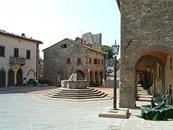
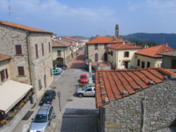
Civitella in Val di Chiana (official name), often also Civitella di Val di Chiana, is a comune in the province of Arezzo, south of Arezzo in Tuscany, Italy. It is one of the best-preserved of the network of Lombard fortresses of the 6th and the 7th century in central Italy, strategically placed to control the whole territory. The characteristic elliptical shape of the military settlements can still be seen in the layout of the town walls.

- ^ "Superficie di Comuni Province e Regioni italiane al 9 ottobre 2011". Italian National Institute of Statistics. Retrieved 16 March 2019.
- ^ "Popolazione Residente al 1° Gennaio 2018". Italian National Institute of Statistics. Retrieved 16 March 2019.


