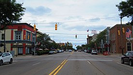
Clare, Michigan | |
|---|---|
| City of Clare | |
 | |
| Nickname: "The Crossroads of Michigan" | |
 Location within Clare County (top) and Isabella County (bottom) | |
| Coordinates: 43°49′10″N 84°46′07″W / 43.81944°N 84.76861°W | |
| Country | United States |
| State | Michigan |
| Counties | Clare and Isabella |
| Founded | 1870 |
| Incorporated | 1885 (village) 1891 (city) |
| Government | |
| • Type | City commission |
| • Mayor | Pat Humphrey |
| • Clerk | Diane Lyon |
| • Manager | Jeremy Howard |
| Area | |
• Total | 3.83 sq mi (9.92 km2) |
| • Land | 3.72 sq mi (9.63 km2) |
| • Water | 0.11 sq mi (0.28 km2) |
| Elevation | 837 ft (255 m) |
| Population (2020) | |
• Total | 3,254 |
| • Density | 874.26/sq mi (337.53/km2) |
| Time zone | UTC-5 (Eastern (EST)) |
| • Summer (DST) | UTC-4 (EDT) |
| ZIP code(s) | 48617 |
| Area code | 989 |
| FIPS code | 26-15920[3] |
| GNIS feature ID | 0623335[4] |
| Website | cityofclare |
Clare is a city in the U.S. state of Michigan. Located near the center of Michigan's Lower Peninsula, the city is located mostly in Clare County, while a small portion extends south into Isabella County. The city had a population of 3,254 at the 2020 census.[5]
Clare was settled as early as 1870 and contains two listings on the National Register of Historic Places: the Clare Downtown Historic District and the Clare Congregational Church. The city is located along the junction of U.S. Route 10 and U.S. Route 127, and each highway has a business route (Bus. 10 and Bus. US 127) through the downtown area. M-115 also runs through the city. The convergence of these highways as well as the historic junction of the Ann Arbor and Pere Marquette railroads has led to the city being nicknamed the "Crossroads of Michigan".[6]
- ^ City of Clare (2022). "Clare: Government". Archived from the original on September 20, 2022. Retrieved September 13, 2022.
- ^ "2020 U.S. Gazetteer Files". United States Census Bureau. Retrieved May 21, 2022.
- ^ "U.S. Census website". United States Census Bureau. Retrieved 2008-01-31.
- ^ U.S. Geological Survey Geographic Names Information System: Clare, Michigan
- ^ Bureau, US Census. "Search Results". The United States Census Bureau. Retrieved 2022-02-27.
{{cite web}}:|last=has generic name (help) - ^ "Hotel History – Doherty Hotel". Retrieved 2024-09-15.

