| Clare | |
|---|---|
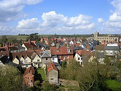
 View over Clare from castle motte | |
Location within Suffolk | |
| Area | 9.26 km2 (3.58 sq mi) |
| Population | 2,028 (2011 Census) |
| • Density | 219/km2 (570/sq mi) |
| OS grid reference | TL770456 |
| Civil parish |
|
| District | |
| Shire county | |
| Region | |
| Country | England |
| Sovereign state | United Kingdom |
| Post town | SUDBURY |
| Postcode district | CO10 |
| Dialling code | 01787 |
| Police | Suffolk |
| Fire | Suffolk |
| Ambulance | East of England |
| UK Parliament | |
Clare is a market town and civil parish on the north bank of the River Stour in the West Suffolk district, in the county of Suffolk, England. Clare is in southwest Suffolk, 14 miles (23 km) from Bury St Edmunds and 9 miles (14 km) from Sudbury.[1] Clare won Village of the Year in 2010 and Anglia in Bloom award for Best Large Village 2011 for its floral displays in 2011. In March 2015, The Sunday Times and Zoopla[2] placed Clare amongst the top 50 UK rural locations, having "period properties and rich history without the chocolate-box perfection – and the coach trips". In 2011 it had a population of 2028.
Clare and its vicinity has evidence of human habitation throughout prehistory, through the Norman Conquest, to the present day.
The town hosts Stour Valley Community School, one of the first free schools established by the government,[3] opened in September 2011.
- ^ "South and Heart of Suffolk". Archived from the original on 8 July 2017. Retrieved 24 August 2016.
- ^ Sunday Times, supplement: Best Places to Live: Rural, 1 March 2015
- ^ "Clare: "Monumental day for whole community" – Suffolk's first-ever free school starts new term". East Anglian Daily Press. 5 September 2011. Retrieved 13 June 2017.
