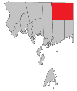
Clarendon Parish
Paroisse de Clarendon | |
|---|---|
 Location within Charlotte County. | |
| Country | |
| Province | |
| County | Charlotte County |
| Erected | 1869 |
| Named for | George Villiers, 4th Earl of Clarendon |
| Area | |
| • Land | 492.11 km2 (190.00 sq mi) |
| Population (2021)[1] | |
• Total | 66 |
| • Density | 0.1/km2 (0.3/sq mi) |
| • Change 2016-2021 | |
| • Dwellings | 64 |
| Time zone | UTC-4 (AST) |
| • Summer (DST) | UTC-3 (ADT) |
Clarendon is a geographic parish in Charlotte County, New Brunswick, Canada,[4] located in the interior to the north of Point Lepreau and southwest of CFB Gagetown.
For governance purposes, Clarendon is part of the Capital Region rural district,[5] which is a member of the Capital Region Regional Service Commission.[6]
Prior to the 2023 governance reform, the parish comprised a single local service district (LSD), which was a member of Capital Region Service Commission (RSC11).[7]
The Census subdivision of the same name shares the parish's boundaries.[1]
- ^ a b c "Census Profile". Statistics Canada. 26 October 2022. Retrieved 29 October 2022.
- ^ "Chapter T-3 Territorial Division Act". Government of New Brunswick. Retrieved 5 June 2023.
- ^ "Chapter I-13 Interpretation Act". Government of New Brunswick. Retrieved 5 June 2023.
- ^ The Territorial Division Act[2] divides the province into 152 parishes, the cities of Saint John and Fredericton, and one town of Grand Falls. The Interpretation Act[3] clarifies that parishes include any local government within their borders.
- ^ "Regional Service Commission 11: RD 11". Government of New Brunswick. Retrieved 5 June 2023.
- ^ "Regions Regulation – Regional Service Delivery Act". Government of New Brunswick. 21 July 2022. Retrieved 5 June 2023.
- ^ "Communities in each of the 12 Regional Service Commissions (RSC) / Les communautés dans chacune des 12 Commissions de services régionaux (CSR)" (PDF), Government of New Brunswick, July 2017, retrieved 2 February 2021