Native name: lungtalanana | |
|---|---|
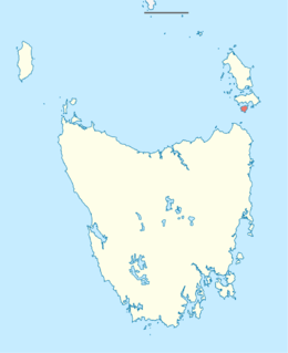
 Lying below Flinders Island and Cape Barren Island is Clarke Island. The land mass at the bottom left corner is Tasmania. | |
 Clarke Island (Tasmania) | |
| Geography | |
| Location | Bass Strait |
| Coordinates | 40°32′06″S 148°10′12″E / 40.535°S 148.170°E |
| Archipelago | Furneaux Group |
| Area | 82 km2 (32 sq mi) |
| Area rank | 8th in Tasmania |
| Highest elevation | 206 m (676 ft)[1] |
| Administration | |
Australia | |
| State | Tasmania |
The Clarke Island, also known by its Indigenous name of lungtalanana, part of the Furneaux Group, is an 82-square-kilometre (32 sq mi) island in Bass Strait, south of Cape Barren Island, about 24 kilometres (15 mi) off the northeast coast of Tasmania, Australia. Banks Strait separates the island from Cape Portland on the mainland. Clarke Island is the third-largest island in the Furneaux Group, and Tasmania's eighth largest island.
Off its west coast lies the shipwreck of HMS Litherland, which sank in 1853 and was discovered in 1983.