Clarksburg, Maryland | |
|---|---|
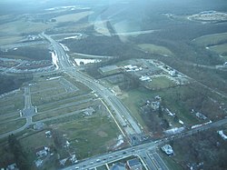
 Aerial view of Clarksburg in January 2007 | |
 Location of Clarksburg, Maryland | |
| Coordinates: 39°14′30″N 77°15′05″W / 39.24167°N 77.25139°W | |
| Country | |
| State | |
| County | |
| Founded | 1752[1] |
| Area | |
• Total | 9.96 sq mi (25.79 km2) |
| • Land | 9.65 sq mi (24.99 km2) |
| • Water | 0.31 sq mi (0.80 km2) |
| Elevation | 551 ft (168 m) |
| Population (2020) | |
• Total | 29,051 |
| • Density | 3,010.78/sq mi (1,162.51/km2) |
| Time zone | UTC−5 (Eastern (EST)) |
| • Summer (DST) | UTC−4 (EDT) |
| ZIP code | 20871 |
| Area code(s) | 301, 240 |
| FIPS code | 24-17350 |
| GNIS feature ID | 2389325[3] |
Clarksburg is a census-designated place and an unincorporated area in northern Montgomery County, Maryland, United States. It is located at the northern end of the Interstate 270 technology corridor, approximately four miles north of Germantown. As of the 2020 census, Clarksburg had a population of 29,051.[4]

- ^ Brocker, Jim (January 7, 2012). "Clarksburg, a work in progress". The Washington Post. p. E4. ProQuest 914465801.
- ^ "2020 U.S. Gazetteer Files". United States Census Bureau. Retrieved April 26, 2022.
- ^ a b U.S. Geological Survey Geographic Names Information System: Clarksburg, Maryland
- ^ "QuickFacts: Clarksburg CDP, Maryland". United States Census Bureau. Retrieved August 16, 2021.
