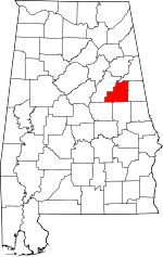
Clay County | |
|---|---|
 Clay County Courthouse in Ashland | |
 Location within the U.S. state of Alabama | |
 Alabama's location within the U.S. | |
| Coordinates: 33°16′20″N 85°51′40″W / 33.2722°N 85.8611°W | |
| Country | |
| State | |
| Founded | December 7, 1866 |
| Named for | Henry Clay |
| Seat | Ashland |
| Largest city | Lineville |
| Area | |
| • Total | 606 sq mi (1,570 km2) |
| • Land | 604 sq mi (1,560 km2) |
| • Water | 2.0 sq mi (5 km2) 0.3% |
| Population (2020) | |
| • Total | 14,236 |
| • Estimate (2023) | 14,111 |
| • Density | 23/sq mi (9.1/km2) |
| Time zone | UTC−6 (Central) |
| • Summer (DST) | UTC−5 (CDT) |
| Congressional district | 3rd |
| Website | alabamaclaycounty |
| |
Clay County is a county in the east central part of the U.S. state of Alabama. As of the 2020 census the population was 14,236.[1] Its county seat is Ashland.[2] Its name is in honor of Henry Clay, famous American statesman, member of the United States Senate from Kentucky and United States Secretary of State in the 19th century. It was the last dry county in Alabama with no wet cities within its boundaries, until a vote on March 1, 2016, approved the sale of alcohol in Lineville and Ashland.[3]
- ^ "State & County QuickFacts". United States Census Bureau. Retrieved September 9, 2023.
- ^ "Find a County". National Association of Counties. Archived from the original on May 31, 2011. Retrieved June 7, 2011.
- ^ "Alabama's last dry county legalizes alcohol sales". USA Today. Retrieved March 3, 2016.