Clay County | |
|---|---|
 West Point City Hall at West Point Central City Historic District. | |
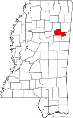
 Location within the U.S. state of Mississippi | |
 Mississippi's location within the U.S. | |
| Coordinates: 33°39′N 88°46′W / 33.65°N 88.77°W | |
| Country | |
| State | |
| Founded | 1871 |
| Named for | Henry Clay |
| Seat | West Point |
| Largest city | West Point |
| Area | |
• Total | 416 sq mi (1,080 km2) |
| • Land | 410 sq mi (1,100 km2) |
| • Water | 5.9 sq mi (15 km2) 1.4% |
| Population (2020) | |
• Total | 18,636 |
• Estimate (2023) | 18,206 |
| • Density | 45/sq mi (17/km2) |
| Time zone | UTC−6 (Central) |
| • Summer (DST) | UTC−5 (CDT) |
| Congressional district | 1st |
| Website | www |
Clay County is a county in the U.S. state of Mississippi. As of the 2020 census, the population was 18,636.[1] Its county seat is West Point.[2] Its name is in honor of American statesman Henry Clay,[3] member of the United States Senate from Kentucky and United States Secretary of State in the 19th century. J. Wesley Caradine, an African American, was the first state representative for Clay County after it was established in 1871.[4] The federal government formerly designated Clay County as the West Point Micropolitan Statistical Area, but the county lost that status in 2013.[5] It is part of the Golden Triangle region of the state.[6]
- ^ "Census - Geography Profile: Clay County, Mississippi". United States Census Bureau. Retrieved January 8, 2023.
- ^ "Find a County". National Association of Counties. Archived from the original on May 31, 2011. Retrieved June 7, 2011.
- ^ Gannett, Henry (1905). The Origin of Certain Place Names in the United States. Govt. Print. Off. p. 83.
- ^ Lowry, Robert; McCardle, William H. (October 12, 1891). A History of Mississippi: From the Discovery of the Great River by Hernando DeSoto, Including the Earliest Settlement Made by the French Under Iberville, to the Death of Jefferson Davis. R.H. Henry & Company. ISBN 9780788448218 – via Google Books.
- ^ "OMB Bulletin No. 13-01: Revised Delineations of Metropolitan Statistical Areas, Micropolitan Statistical Areas, and Combined Statistical Areas, and Guidance on Uses of the Delineations of These Areas" (PDF). United States Office of Management and Budget. February 28, 2013. Retrieved April 3, 2013.
- ^ "Golden Triangle economic development model could be emulated across state". Archived from the original on March 7, 2015. Retrieved May 20, 2014.