Clayton, Michigan | |
|---|---|
| Village of Clayton | |
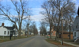
 Facing north along State Street | |
 Location within Lenawee County | |
| Coordinates: 41°51′49″N 84°14′07″W / 41.86361°N 84.23528°W | |
| Country | United States |
| State | Michigan |
| County | Lenawee |
| Townships | Dover and Hudson |
| Established | 1836 |
| Platted | 1843 |
| Incorporated | 1870 |
| Government | |
| • Type | Village council |
| • President | Shannon Johnston |
| • Clerk | Wendy Mullane |
| Area | |
| • Total | 0.71 sq mi (1.84 km2) |
| • Land | 0.71 sq mi (1.84 km2) |
| • Water | 0.00 sq mi (0.00 km2) |
| Elevation | 896 ft (273 m) |
| Population (2020) | |
| • Total | 311 |
| • Density | 436.80/sq mi (168.77/km2) |
| Time zone | UTC-5 (Eastern (EST)) |
| • Summer (DST) | UTC-4 (EDT) |
| ZIP code(s) | 49235 |
| Area code | 517 |
| FIPS code | 26-16280[3] |
| GNIS feature ID | 0623395[4] |
| Website | Official website |
Clayton is a village in Lenawee County of the U.S. state of Michigan. The population was 311 at the 2020 census. The village is located within Hudson Township to the west and Dover Township to the east.
- ^ Lenawee County (2022). "Lenawee County, Michigan Government Directory". p. 37. Retrieved June 15, 2022.
- ^ "2020 U.S. Gazetteer Files". United States Census Bureau. Retrieved May 21, 2022.
- ^ "U.S. Census website". United States Census Bureau. Retrieved January 31, 2008.
- ^ "US Board on Geographic Names". United States Geological Survey. October 25, 2007. Retrieved January 31, 2008.

