| Clear Creek[1] | |
|---|---|
 | |
 | |
| Physical characteristics | |
| Source | |
| • location | Clear Creek County, Colorado |
| • coordinates | 39°40′29″N 105°55′23″W / 39.67472°N 105.92306°W |
| Mouth | |
• location | Confluence with South Platte |
• coordinates | 39°49′39″N 104°56′57″W / 39.82750°N 104.94917°W |
• elevation | 5,092 ft (1,552 m) |
| Length | 66 mi (106 km) |
| Discharge | |
| • location | Golden, Colorado[2] |
| • average | 191 cu/ft. per sec. |
| Basin features | |
| Progression | South Platte—Platte— Missouri—Mississippi |
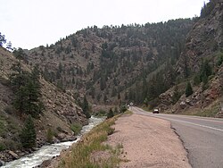
Clear Creek is a tributary of the South Platte River, approximately 66 miles (106 km) long,[3] in north central Colorado in the United States. The creek flows through Clear Creek Canyon in the Rocky Mountains directly west of Denver, descending through a long gorge to emerge at the town of Golden, finally ending in the Colorado Eastern Plains where it joins the South Platte. Clear Creek is unusual in that it is a stream named "creek" fed by a stream named "river"; typically "rivers" are fed by "creeks", and are larger bodies of water, although the nomenclature is ambiguous and there is no clear system. Fall River empties into Clear Creek along I-70 west of Idaho Springs, Colorado.
- ^ "Clear Creek". Geographic Names Information System. United States Geological Survey, United States Department of the Interior. Retrieved 2011-01-26.
- ^ "USGS Current Conditions for USGS 06719505 CLEAR CREEK AT GOLDEN, CO".
- ^ U.S. Geological Survey. National Hydrography Dataset high-resolution flowline data. The National Map Archived 2016-06-30 at the Wayback Machine, accessed March 25, 2011