| Clifton Campville | |
|---|---|
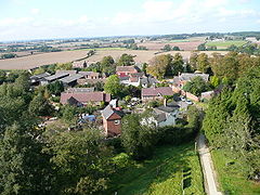
 Clifton Campville from above | |
Location within Staffordshire | |
| Population | 912 (2011)[1] |
| OS grid reference | SK255110 |
| Civil parish |
|
| District | |
| Shire county | |
| Region | |
| Country | England |
| Sovereign state | United Kingdom |
| Post town | TAMWORTH |
| Postcode district | B79 |
| Dialling code | 01827 |
| Police | Staffordshire |
| Fire | Staffordshire |
| Ambulance | West Midlands |
| UK Parliament | |
Clifton Campville is a village, former manor and civil parish[3] in Staffordshire, England.[4] It lies on the River Mease, about 10 miles (16 km) east of the City of Lichfield, 6 miles (10 km) west of Measham and 7 miles (11 km) north of Tamworth. The village lies close to Staffordshire's borders with Derbyshire, Leicestershire and Warwickshire. The parish, which includes Haunton village, had a population of 912 at the 2011 census.[1] There is a fine gothic church, dedicated to St Andrew, and listed Grade I. The village pub, The Green Man, is also a historic building.
- ^ a b "Civil Parish population 2011". Retrieved 6 December 2015.
- ^ Cite error: The named reference
parlwas invoked but never defined (see the help page). - ^ Cite error: The named reference
ons-cpwas invoked but never defined (see the help page). - ^ OS Explorer Map 232 : Nuneaton & Tamworth: (1:25 000) :ISBN 0 319 46404 0
