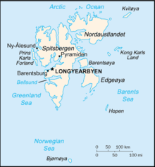

Svalbard is a Norwegian archipelago in the Arctic Ocean. The climate of Svalbard is principally a result of its latitude, which is between 74° and 81° north. Climate is defined by the World Meteorological Organization as the average weather over a 30-year period.[1] The North Atlantic Current moderates Svalbard's temperatures, particularly during winter, giving it up to 20 °C (36 °F) higher winter temperature than similar latitudes in continental Russia and Canada. This keeps the surrounding waters open and navigable most of the year. The interior fjord areas and valleys, sheltered by the mountains, have fewer temperature differences than the coast, with about 2 °C lower summer temperatures and 3 °C higher winter temperatures. On the south of the largest island, Spitsbergen, the temperature is slightly higher than further north and west. During winter, the temperature difference between south and north is typically 5 °C, and about 3 °C in summer. Bear Island (Bjørnøya) has average temperatures even higher than the rest of the archipelago.[2]
Svalbard is located in between two ocean currents – the warm Atlantic West Spitsbergen Current and the cold Arctic East Spitsbergen Current.[3] These currents have a large impact on the climate of Svalbard and in the distribution of sea ice. The warm Atlantic current on the west coast leads to an average sea temperature of 5–7 °C.[4] This causes a difference in sea ice distribution on Svalbard, with the east coast having a significantly larger area of ice-covered sea than the west coast.[4]
- ^ PWMU. "World Meteorological Organization (WMO) -". www.wmo.int. Retrieved 11 May 2018.
- ^ Torkilsen (1984): 98–99
- ^ Ślubowska, Marta A.; Koç, Nalân; Rasmussen, Tine L.; Klitgaard-Kristensen, Dorthe (23 November 2005). "Changes in the flow of Atlantic water into the Arctic Ocean since the last deglaciation: Evidence from the northern Svalbard continental margin, 80°N". Paleoceanography. 20 (4): n/a. Bibcode:2005PalOc..20.4014A. doi:10.1029/2005pa001141. hdl:11250/174160. ISSN 0883-8305.
- ^ a b Przybylak, Rajmund; Araźny, Andrzej; Kejna, Marek (1 January 2012). Introduction, in: Topoclimatic Diversity in Forlandsundet Region (NW Spitsbergen) in Global Warming Conditions, Edited by Przybylak et al. 2012. pp. 7–25. ISBN 9788389743060.