Clinton, Maryland | |
|---|---|
 The Surratt House in 2006 | |
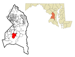
 Location of Clinton, Maryland | |
| Coordinates: 38°45′49″N 76°53′44″W / 38.76361°N 76.89556°W | |
| Country | |
| State | |
| County | |
| Area | |
• Total | 25.09 sq mi (64.99 km2) |
| • Land | 25.02 sq mi (64.79 km2) |
| • Water | 0.08 sq mi (0.20 km2) |
| Elevation | 249 ft (76 m) |
| Population (2020) | |
• Total | 38,760 |
| • Density | 1,549.35/sq mi (598.21/km2) |
| Time zone | UTC−5 (Eastern (EST)) |
| • Summer (DST) | UTC−4 (EDT) |
| ZIP code | 20735 |
| Area code(s) | 301, 240 |
| FIPS code | 24-17900 |
| GNIS feature ID | 0597253 |
Clinton is an unincorporated census-designated place (CDP) in Prince George's County, Maryland, United States.[2] Clinton was formerly known as Surrattsville until after the time of the Civil War. The population of Clinton was 38,760 at the 2020 census.[3] Clinton is historically known for its role in the American Civil War concerning the Abraham Lincoln assassination. Clinton is adjacent to Camp Springs, Rosaryville, Melwood, and Andrews Air Force Base.
- ^ "2020 U.S. Gazetteer Files". United States Census Bureau. Retrieved April 26, 2022.
- ^ U.S. Geological Survey Geographic Names Information System: Clinton, Maryland
- ^ "Clinton CDP, Maryland". United States Census Bureau. Retrieved March 13, 2022.