| Cloquet River | |
|---|---|
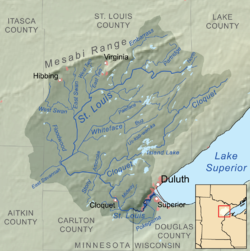
 Map of the Saint Louis River drainage basin showing the Cloquet River | |
| Location | |
| Country | United States |
| State | Minnesota |
| Counties | Lake, St. Louis |
| Physical characteristics | |
| Source | |
| • location | Cloquet Lake, Silver Creek Township, Lake County, Minnesota |
| • coordinates | 47°25′53″N 91°29′12″W / 47.4313058°N 91.4865513°W |
| Mouth | |
• location | Saint Louis River at Culver Township, St. Louis County, Minnesota |
• coordinates | 46°51′41″N 92°34′13″W / 46.86139°N 92.57028°W |
| Length | 104 miles (167 km) |
| Basin features | |
| Progression | Cloquet River→ Saint Louis River→ Lake Superior |
The Cloquet River is a 104-mile-long (167 km)[1] river in Minnesota, United States. It is the main tributary of the Saint Louis River.[2]
- ^ "National Hydrography Dataset high-resolution flowline data". U.S. Geological Survey. Archived from the original on 2012-03-29. Retrieved 2012-09-28., accessed May 7, 2012
- ^ U.S. Geological Survey Geographic Names Information System: Cloquet River
