Clutha District | |
|---|---|
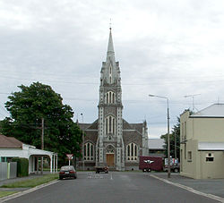
 Tokomairiro Presbyterian Church, Milton | |
 Clutha district in the South Island | |
| Coordinates: 46°05′S 169°33′E / 46.09°S 169.55°E | |
| Country | New Zealand |
| Region | Otago |
| Communities |
|
| Wards |
|
| Seat | Balclutha |
| Government | |
| • Mayor | Bryan Cadogan |
| • Deputy Mayor | Ken Payne[1] |
| • Territorial authority | Clutha District Council |
| Area | |
| • Land | 6,334.54 km2 (2,445.78 sq mi) |
| Population (June 2024)[3] | |
| • Total | 19,300 |
| Time zone | UTC+12 (NZST) |
| • Summer (DST) | UTC+13 (NZDT) |
| Postcode(s) | |
| Area code | 03 |
| Website | www |
Clutha District is a local government district of southern New Zealand, with its headquarters in the Otago town of Balclutha. Clutha District has a land area of 6,334.47 km2 (2,445.75 sq mi) and an estimated population of 19,300 as of June 2024. Clutha District occupies the majority of the geographical area known as South Otago.
- ^ "Mayor and Councillors". www.cluthadc.govt.nz. Clutha District Council. Retrieved 19 April 2024.
- ^ Cite error: The named reference
Areawas invoked but never defined (see the help page). - ^ "Aotearoa Data Explorer". Statistics New Zealand. Retrieved 26 October 2024.