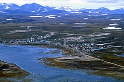
Clyde River
ᑲᖏᖅᑐᒑᐱᒃ Kangiqtugaapik | |
|---|---|
 Clyde River 1997 | |
| Coordinates: 70°28′05″N 068°35′40″W / 70.46806°N 68.59444°W[1] | |
| Country | Canada |
| Territory | Nunavut |
| Region | Qikiqtaaluk |
| Electoral district | Uqqummiut |
| Government | |
| • Mayor | Alan Cormack |
| • MLA | Mary Killiktee |
| Area (2021)[5] | |
| • Land | 103.38 km2 (39.92 sq mi) |
| Elevation | 27 m (89 ft) |
| Population (2021)[5] | |
• Total | 1,181 |
| • Density | 11.4/km2 (30/sq mi) |
| Time zone | UTC−05:00 (EST) |
| • Summer (DST) | UTC−04:00 (EDT) |
| Canadian Postal code | |
| Area code | 867 |
Clyde River (Syllabics: ᑲᖏᖅᑐᒑᐱᒃ,[7] Inuktitut: Kangiqtugaapik "nice little inlet"[8]) is an Inuit hamlet located on the shore of Baffin Island's Patricia Bay, off Kangiqtugaapik,[9] an arm of Davis Strait in the Qikiqtaaluk Region of Nunavut, Canada. It lies in the Baffin Mountains which in turn form part of the Arctic Cordillera mountain range. The community is served by air and by annual supply sealift.
The community is served by Quluaq School, the Northern Stores, an arena, a community hall, an Anglican church (the Church of the Redeemer[10]), a health centre, hotel and Clyde River Airport with regular flights to Iqaluit and Pond Inlet.
- ^ "Clyde River". Geographical Names Data Base. Natural Resources Canada.
- ^ "Municipal Election Results 2019-2020" (PDF). Elections Nunavut. Retrieved December 26, 2022.
- ^ "2021 General Election" (PDF). Elections Nunavut. Retrieved December 26, 2022.
- ^ "Clyde River still searching for diesel after declaring state of emergency". Nunatsiaq News. February 14, 2022. Retrieved December 26, 2022.
- ^ a b Cite error: The named reference
2021censuswas invoked but never defined (see the help page). - ^ Elevation at airport. Canada Flight Supplement. Effective 0901Z 16 July 2020 to 0901Z 10 September 2020.
- ^ Clyde River official site in syllabics
- ^ Clyde River official site in English
- ^ "Nunavut Communities". 2007 Western Premiers' Conference. gov.nu.ca. Archived from the original on October 15, 2008. Retrieved September 29, 2008.
- ^ "Clyde River". Archived from the original on March 16, 2016. Retrieved March 12, 2016.


