This article includes a list of general references, but it lacks sufficient corresponding inline citations. (September 2013) |
| Clyde River | |
|---|---|
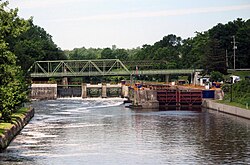
 The Clyde River begins at Erie Canal Lock #27 in Lyons, New York. This view is looking upstream towards the lock. | |
| Location | |
| Country | United States |
| State | New York |
| Region | Finger Lakes |
| Physical characteristics | |
| Source | Confluence of the Canandaigua Outlet, Ganargua Creek and Erie Canal at Lock #27 |
| • location | Lyons, Wayne County, New York, United States |
| • coordinates | 43°03′43.08″N 76°59′45.92″W / 43.0619667°N 76.9960889°W |
| • elevation | 385 ft (117 m) |
| Mouth | Seneca River |
• location | Tyre, Seneca County, New York, United States |
• coordinates | 42°59′57.69″N 76°43′50.88″W / 42.9993583°N 76.7308000°W |
• elevation | 374 ft (114 m) |
| Length | 27 mi (43 km) |
| Basin size | 191 sq mi (490 km2) |
| Discharge | |
| • location | Lyons, New York |
| Basin features | |
| Tributaries | |
| • left | Black Brook (into Erie Canal), Melvin Brook (into Erie Canal) |
| • right | Pond Brook, White Brook |
The Clyde River is a main tributary which feeds the Seneca River in Seneca County, New York, United States. It begins at the hamlet of Lyons in nearby Wayne County and meanders for approximately 27 miles (43 kilometers) from west to east before emptying into the Seneca River in the town of Tyre at Montezuma National Wildlife Refuge. Much of the original river has been channeled through to form part of the Erie Canal. A number of tributaries feed the Clyde River along its route.
The Clyde River is part of the Seneca River watershed which feeds the Oswego River. From there, the Oswego River enters Lake Ontario. It is a primary spot for fishing, flatwater canoeing and kayaking.

