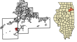
Coal City, Illinois | |
|---|---|
 Location within counties and Illinois | |
 Location of Illinois in the United States | |
| Coordinates: 41°16′47″N 88°16′39″W / 41.27972°N 88.27750°W | |
| Country | United States |
| State | Illinois |
| County | Grundy, Will |
| Townships | Braceville · Felix |
| Area | |
| • Total | 5.88 sq mi (15.23 km2) |
| • Land | 5.77 sq mi (14.94 km2) |
| • Water | 0.11 sq mi (0.29 km2) |
| Elevation | 568 ft (173 m) |
| Population (2020) | |
| • Total | 5,705 |
| • Density | 989.25/sq mi (381.94/km2) |
| Time zone | UTC-6 (CST) |
| • Summer (DST) | UTC-5 (CDT) |
| ZIP Code(s) | 60416 |
| Area code(s) | 815, 779 |
| FIPS code | 17-15170 |
| GNIS feature ID | 2398586[2] |
| Website | coalcity-il.gov |
| [3] | |
Coal City is a village in Grundy and Will Counties in the U.S. state of Illinois. It is considered a fringe town of the Chicago metropolitan area. The population was 5,705 at the 2020 census.[4]
- ^ "2020 U.S. Gazetteer Files". United States Census Bureau. Retrieved March 15, 2022.
- ^ a b U.S. Geological Survey Geographic Names Information System: Coal City, Illinois
- ^ "Geographic Names Information System". United States Geological Survey. Retrieved 2008-01-31.
- ^ "Explore Census Data". data.census.gov. Retrieved 2022-06-28.

