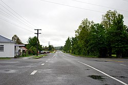
Coalgate | |
|---|---|
Village | |
 Bridge Street, November 2011 | |
 | |
| Coordinates: 43°29′S 171°58′E / 43.483°S 171.967°E | |
| Country | New Zealand |
| Region | Canterbury |
| Territorial authority | Selwyn District |
| Ward | Malvern |
| Community | Malvern |
| Electorates |
|
| Government | |
| • Territorial authority | Selwyn District Council |
| • Regional council | Environment Canterbury |
| • Mayor of Selwyn | Sam Broughton |
| • Selwyn MP | Nicola Grigg |
| • Te Tai Tonga MP | Tākuta Ferris |
| Area | |
| • Total | 1.09 km2 (0.42 sq mi) |
| Population (June 2023)[2] | |
| • Total | 380 |
| • Density | 350/km2 (900/sq mi) |
| Time zone | UTC+12 (New Zealand Standard Time) |
| • Summer (DST) | UTC+13 (New Zealand Daylight Time) |
| Area code | 03 |
Coalgate is a small town in the Selwyn District of the Canterbury region of New Zealand's South Island.[3] It is located roughly an hour west of Christchurch on State Highway 77. The town's name stems from it being the "gateway" to the lignite coal fields around Whitecliffs, the Rakaia Gorge, and The Acheron River. Coal mining declined in the 20th century and has now ceased, but since the 1950s, commercial processing of nontronite has taken place in Coalgate.[4]
- ^ Cite error: The named reference
Areawas invoked but never defined (see the help page). - ^ "Subnational population estimates (RC, SA2), by age and sex, at 30 June 1996-2023 (2023 boundaries)". Statistics New Zealand. Retrieved 25 October 2023. (regional councils); "Subnational population estimates (TA, SA2), by age and sex, at 30 June 1996-2023 (2023 boundaries)". Statistics New Zealand. Retrieved 25 October 2023. (territorial authorities); "Subnational population estimates (urban rural), by age and sex, at 30 June 1996-2023 (2023 boundaries)". Statistics New Zealand. Retrieved 25 October 2023. (urban areas)
- ^ "Place name detail: Coalgate". New Zealand Gazetteer. New Zealand Geographic Board. Retrieved 2 April 2008.
- ^ Selwyn District Council, "Glentunnel and Coalgate" Archived 17 September 2008 at the Wayback Machine, accessed 19 May 2008.