Coastal Andhra
Kōstā Āndhra | |
|---|---|
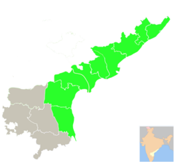
 Coastal Andhra region (old districts) highlighted in Andhra Pradesh | |
| Country | |
| State | |
| Districts |
|
| Largest city | |
| Major Cities | |
| Area | |
• Total | 91,915 km2 (35,489 sq mi) |
| Population (2011)[2] | |
• Total | 34,195,655 |
| Languages | |
| • Official | Telugu |
| Time zone | UTC+05:30 (IST) |
| Vehicle registration | AP05, AP06, AP07, AP08, AP16, AP18, AP26, AP27, AP37, AP39 |
| Largest airport | Visakhapatnam Airport |
Coastal Andhra, also known as Kosta Andhra (IAST: Kōstā Āndhra), is a geographic region in the Indian state of Andhra Pradesh, comprising the coastal districts of the state between the Eastern Ghats and the Bay of Bengal, from the northern border with Orissa to Rayalaseema in the south.[3] It includes major cities such as Visakhapatnam and Vijayawada as well as the state capital Amaravati and is recognized for its fertile lands, rich cultural heritage, and economic importance. Coastal Andhra plays a significant role in the state's agricultural output, particularly in rice and tobacco production, supported by abundant water resources from the Godavari, Krishna, and Penna rivers.[4][5]
While Coastal Andhra generally includes the districts along the Bay of Bengal, the Uttarandhra (Northern Andhra) area is sometimes regarded as distinct due to its unique cultural and historical background. Coastal Andhra shares borders with the Rayalaseema region of Andhra Pradesh and the state of Telangana. Covering an area of 91,915 square kilometres (35,489 sq mi), Coastal Andhra accounts for 58% of Andhra Pradesh's total area and, as per the 2011 Census of India, hosts a population of over 3.4 crore, constituting 69.20% of the state’s population. Coastal Andhra was formerly part of the Madras State until 1953 and then became part of Andhra State from 1953 to 1956.[3]
Historically, Coastal Andhra has been a centre of trade and culture, featuring strong traditions in literature, music, and dance. The region contributed actively to the Indian independence movement and continues to impact the state’s economy through industries such as information technology, petroleum, and pharmaceuticals. It is also home to major ports in Visakhapatnam and Kakinada, enhancing its status as a critical industrial and trading hub. Proximity to the Bay of Bengal, however, makes the region susceptible to tropical cyclones and coastal erosion, prompting investments in disaster preparedness and coastal management initiatives.[3]
- ^ "Andhra Pradesh Fact Sheet". mapsofindia.com.
- ^ "Wayback Machine" (PDF). 12 November 2013. Archived from the original (PDF) on 12 November 2013. Retrieved 24 February 2023.
- ^ a b c Ojha, Shreya (November 2019). "Demographic Profile of Coastal Andhra Pradesh, India" (PDF). International Journal of Scientific & Engineering Research. 10 (11). ISSN 2229-5518.
- ^ Rao, Desari Panduranga (1985). Trends in Indian Transport System: A Districtwise Study. Inter-India Publications. p. 158. ISBN 978-0-86590-701-0.
- ^ "Indian States fish production" (PDF).


