Cocos (Keeling) Islands Airport Lapangan Terbang Pulu Kokos (Cocos Islands Malay) | |||||||||||
|---|---|---|---|---|---|---|---|---|---|---|---|
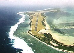
 Aerial view in the direction of Runway 33 | |||||||||||
| Summary | |||||||||||
| Airport type | Public | ||||||||||
| Operator | Toll Remote Logistics | ||||||||||
| Location | West Island, Cocos (Keeling) Islands | ||||||||||
| Elevation AMSL | 10 ft / 3 m | ||||||||||
| Coordinates | 12°11′19″S 096°49′50″E / 12.18861°S 96.83056°E | ||||||||||
| Website | cocosislandairport | ||||||||||
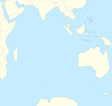
| Map | |||||||||||
| Runways | |||||||||||
| |||||||||||
| Statistics (2010/11[a 1]) | |||||||||||
| |||||||||||

Cocos (Keeling) Islands Airport (Cocos Islands Malay: Lapangan Terbang Pulu Koko (Keeling)) (IATA: CCK, ICAO: YPCC) is an airport serving the Cocos (Keeling) Islands, a territory of Australia located in the Indian Ocean. The airport is on West Island, one of the South Keeling Islands and capital of the territory.
Cite error: There are <ref group=a> tags on this page, but the references will not show without a {{reflist|group=a}} template (see the help page).
- ^ YPCC – Cocos (Keeling) Island (PDF). AIP En Route Supplement from Airservices Australia, effective 13 June 2024, Aeronautical Chart Archived 10 April 2012 at the Wayback Machine
- ^ Cite error: The named reference
BITREwas invoked but never defined (see the help page).


