46°47′S 167°38′E / 46.783°S 167.633°E
Whenua Hou (Māori) | |
|---|---|
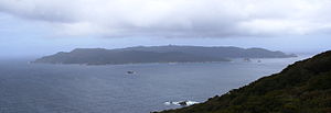
 Codfish Island / Whenua Hou as viewed from neighbouring Rakiura | |
 Map of Stewart Island / Rakiura, with Codfish Island / Whenua Hou to the northwest. | |
| Geography | |
| Location | Tasman Sea |
| Coordinates | 46°47′S 167°38′E / 46.783°S 167.633°E |
| Archipelago | New Zealand archipelago |
| Total islands | 1 |
| Area | 14 km2 (5.4 sq mi) |
| Highest elevation | 250 m (820 ft)[1] |
| Administration | |
| Region | Southland Region |
| Demographics | |
| Population | Uninhabited (2023) |
Codfish Island / Whenua Hou is a small island (14 km2 or 5.4 sq mi) located to the west of Stewart Island in southern New Zealand. It reaches a height of 250 m (820 ft) close to the south coast. The island is home to Sirocco, an internationally famous kākāpō, a rare species of parrot.
- ^ "Codfish Island (Whenuahou), Southland – NZ Topo Map". Land Information New Zealand. Retrieved 2017-10-17.