Coffeeville, Alabama | |
|---|---|
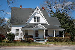
 Victorian house on Alabama State Route 69 in Coffeeville | |
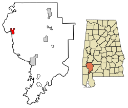
 Location of Coffeeville in Clarke County, Alabama. | |
| Coordinates: 31°45′29″N 88°05′23″W / 31.75806°N 88.08972°W | |
| Country | United States |
| State | Alabama |
| County | Clarke |
| Area | |
| • Total | 4.52 sq mi (11.71 km2) |
| • Land | 4.52 sq mi (11.71 km2) |
| • Water | 0.00 sq mi (0.00 km2) |
| Elevation | 174 ft (53 m) |
| Population (2020) | |
| • Total | 263 |
| • Density | 58.19/sq mi (22.47/km2) |
| Time zone | UTC-6 (Central (CST)) |
| • Summer (DST) | UTC-5 (CDT) |
| ZIP code | 36524 |
| Area code | 251 |
| FIPS code | 01-16264 |
| GNIS feature ID | 116356[2] |
| Website | https://www.townofcoffeeville.org/ |
Coffeeville is a town in Clarke County, Alabama, United States.[2] At the 2020 census, the population was 263.
- ^ "2020 U.S. Gazetteer Files". United States Census Bureau. Retrieved October 29, 2021.
- ^ a b "Coffeeville". Geographic Names Information System. United States Geological Survey, United States Department of the Interior. Retrieved July 18, 2023.