44°39′06″N 63°34′35″W / 44.651742°N 63.576474°W
| Cogswell Interchange | |
|---|---|
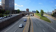
 General view (2016) | |
 | |
| Location | |
| Halifax, Nova Scotia | |
| Roads at junction | Barrington Street, Cogswell Street, Upper Water Street, Hollis Street |
| Construction | |
| Type | Multi-level interchange |
| Spans | 3 |
| Constructed | 1969 |
| Opened | 1970 |
| Maintained by | Halifax Regional Municipality and Province of Nova Scotia |
The Cogswell Interchange was a multi-level highway interchange in downtown Halifax, Nova Scotia, Canada. It was built as the first stage of a greater scheme for an elevated freeway, called Harbour Drive, that would have demolished much of the downtown area. The plan was halted in the face of opposition, but the Cogswell Interchange remained a visible reminder, occupying a large amount of prime land and posing a barrier to pedestrian movement.
As the interchange became functionally obsolete and increasingly expensive to maintain, the municipal government decided to demolish the interchange and replace it with a more conventional street grid. Halifax Regional Council unanimously approved the 90 per cent design construction plan in February 2019 and directed staff to tender demolition and construction contracts for the redevelopment. Work began on the project in March 2022 and the newly renamed Cogswell District is scheduled to be open to the public by late 2025.