| Col de la Bonette | |
|---|---|
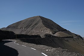
 Cime de la Bonette, viewed from the northern ascent from Jausiers. The Col de la Bonette is marked by the gap in the centre of the picture, while the circle road takes a loop up and around the Cime de la Bonette, before joining the col behind the ridge. | |
| Elevation | 2,715 metres (8,907 ft) or 2,802 metres (9,193 ft) (Cime de la Bonette) |
| Traversed by | D64 |
| Location | Alpes-Maritimes/Alpes-de-Haute-Provence, France |
| Range | Alps |
| Coordinates | 44°19′37.2″N 06°48′25.2″E / 44.327000°N 6.807000°E |
Col de la Bonette (el. 2,715 metres (8,907 ft)) is a high mountain pass in the French Alps, near the border with Italy. It is situated within the Mercantour National Park on the border of the departments of Alpes-Maritimes and Alpes-de-Haute-Provence. The road over the col is the seventh highest paved road in the Alps.
