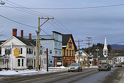
Colebrook, New Hampshire | |
|---|---|
Town | |
 Main Street | |
 Location in Coös County, New Hampshire | |
| Coordinates: 44°53′40″N 71°29′45″W / 44.89444°N 71.49583°W | |
| Country | United States |
| State | New Hampshire |
| County | Coös |
| Incorporated | 1796 |
| Villages |
|
| Government | |
| • Board of Selectmen |
|
| • Town Manager | Tim Stevens |
| Area | |
• Total | 40.72 sq mi (105.46 km2) |
| • Land | 40.51 sq mi (104.92 km2) |
| • Water | 0.21 sq mi (0.54 km2) 0.51% |
| Elevation | 1,024 ft (312 m) |
| Population (2020)[2] | |
• Total | 2,084 |
| • Density | 52/sq mi (19.9/km2) |
| Time zone | UTC-5 (Eastern) |
| • Summer (DST) | UTC-4 (Eastern) |
| ZIP code | 03576 |
| Area code | 603 |
| FIPS code | 33-13780 |
| GNIS feature ID | 0871097 |
| Website | www |
Colebrook is a town in Coös County, New Hampshire, United States. The population was 2,084 at the time of the 2020 census,[2] down from 2,301 at the 2010 census.[3] Situated in the Great North Woods Region, it is bounded on the west by the Connecticut River and home to Beaver Brook Falls Natural Area.
The main village of the town, where 1,201 people resided at the 2020 census, is defined as the Colebrook census-designated place (CDP), and is located at the junction of U.S. Route 3 with New Hampshire Route 26. The town also includes the villages of Kidderville, Upper Kidderville, and Factory Village.
Colebrook is part of the Berlin, New Hampshire micropolitan area.

- ^ "2021 U.S. Gazetteer Files – New Hampshire". United States Census Bureau. Retrieved November 8, 2021.
- ^ a b "Colebrook town, Coos County, New Hampshire: 2020 DEC Redistricting Data (PL 94-171)". U.S. Census Bureau. Retrieved November 8, 2021.
- ^ United States Census Bureau, American FactFinder, 2010 Census figures. Retrieved March 23, 2011.
