This article needs attention from an expert in Illinois or Politics of the United States. The specific problem is: Needs expansion and updates, especially by people who closely follow Illinois politics. (September 2018) |
Collar counties | |
|---|---|
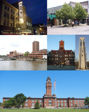
 Clockwise from top left: Rialto Square Theater (Joliet), Downtown Crystal Lake, Moser Tower (Naperville), Old DuPage County Courthouse (Wheaton), Great Lakes Naval Training Station (North Chicago) and Downtown Aurora. | |
 | |
| Country | |
| State | |
| Counties | DuPage, Kane, Lake, McHenry and Will. |
| Settled | 1770s |
| Named for | Their mutual proximity to and surrounding of Cook County. |
| Population (2012 Estimate) | |
• Total | 3,143,257 |
| Time zone | UTC−06:00 (CST) |
| • Summer (DST) | UTC−05:00 (CDT) |
| Area code(s) | 224, 331, 630, 779, 815, 847 |
Collar counties is a colloquialism for DuPage, Kane, Lake, McHenry, and Will counties, the five counties of Illinois that border Cook County, which is home to Chicago. The collar counties are part of the Chicago metropolitan area and comprise many of the area's suburbs. While Lake County, Indiana, also borders Cook County, it is not typically included in the phrase "Collar Counties" due to different socioeconomic characteristics and positionality.
After Cook County, the collar counties are also the next five most populous counties in Illinois. According to the Encyclopedia of Chicago, there is no specifically known origin of the phrase, but it has been commonly used among policy makers, urban planners, and in the media.[4]
In 1950, the Census Bureau defined the Chicago metropolitan statistical area as comprising Cook County, four of the five collar counties (excluding McHenry), and Lake County in Indiana. In 2010, reflecting urban growth, the Bureau redefined the area as comprising several additional counties in Illinois, Indiana, and Wisconsin.[5]
As of 2019, there are 3,150,376 people residing in the collar counties, nearly 25% of the population of Illinois. Cook County and the collar counties combined are home to approximately 65% of Illinois's population.
- ^ Field, Nick (October 25, 2019). "How the Pa. electorate has changed since 2016 and what that means for 2020 | Analysis". Pennsylvania Capital-Star. Retrieved September 22, 2020.
- ^ Otterbein, Holly. "Pennsylvania suburbs revolt against Trump". POLITICO. Retrieved September 22, 2020.
- ^ Bond, Michaelle. "The Philadelphia suburbs turned blue in a big way. What do Democrats plan to do with their new power?". inquirer.com. Retrieved September 22, 2020.
- ^ Mariner, Richard D. (2005), "Collar Counties", Encyclopedia of Chicago, Chicago: Chicago History Museum and the Newberry Library, retrieved March 11, 2021
- ^ "Combined statistical area population and estimated components of change: April 1, 2010 to July 1, 2016 (CSA-EST2016-alldata)". U.S. Census. Retrieved July 27, 2017.