College Hill | |
|---|---|
 The Fleur-de-lys Studios (1885) and Deacon Taylor House (1785) | |
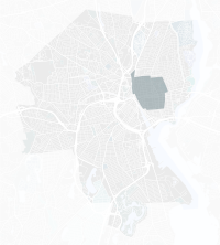
 Location of College Hill within Providence | |
| Coordinates: 41°49′45″N 71°24′03″W / 41.82917°N 71.40083°W | |
| Country | |
| State | |
| City | Providence |
| Area | |
| • Total | 1.99 km2 (0.770 sq mi) |
| Population | |
| • Total | 9,334 |
College Hill is a historic neighborhood of Providence, Rhode Island, and one of six neighborhoods comprising the city's East Side. It is roughly bounded by South and North Main Street to the west, Power Street to the south, Governor Street and Arlington Avenue to the east and Olney Street to the north. The neighborhood's primary commercial area extends along Thayer Street, a strip frequented by students in the Providence area.
College Hill is the most affluent neighborhood in Providence, with a median family income of nearly three times that of the whole city.
Portions of College Hill are designated local and national historic districts for their historical residential architecture. In 2011, the American Planning Association designated the neighborhood one of the "Great Places in America".[1]
- ^ "Great Places in America | American Planning Association". Archived from the original on 2012-03-10. Retrieved 2012-03-27.