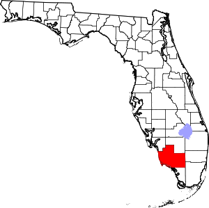
Collier County | |
|---|---|
 The Collier County courthouse in April 2010 | |
 Location within the U.S. state of Florida | |
 Florida's location within the U.S. | |
| Coordinates: 26°05′N 81°24′W / 26.08°N 81.4°W | |
| Country | |
| State | |
| Founded | May 8, 1923 |
| Named for | Barron Collier |
| Seat | East Naples |
| Largest city | Naples |
| Area | |
• Total | 2,305 sq mi (5,970 km2) |
| • Land | 1,998 sq mi (5,170 km2) |
| • Water | 307 sq mi (800 km2) 13.3% |
| Population (2020) | |
• Total | 375,752 |
| • Density | 188/sq mi (73/km2) |
| Time zone | UTC−5 (Eastern) |
| • Summer (DST) | UTC−4 (EDT) |
| Congressional districts | 18th, 19th, 26th |
| Website | www |

Collier County is a county in the U.S. state of Florida. As of the 2020 census, its population was 375,752; an increase of 16.9% since the 2010 United States Census.[1] Its county seat is East Naples,[2] where the county offices were moved from Everglades City in 1962.
Collier County comprises the Naples–Marco Island Metropolitan Statistical Area (MSA), which, along with the Cape Coral-Fort Myers (Lee County) MSA and the Clewiston (Hendry County, Glades County) Micropolitan Statistical Area (μSA), is included in the Cape Coral-Fort Myers-Naples Combined Statistical Area (CSA).[3]
- ^ "Collier County, Florida Demographics and Housing 2020 Decennial Census".
- ^ "Find a County". National Association of Counties. Archived from the original on May 31, 2011. Retrieved June 7, 2011.
- ^ "Revised Delineations of Metropolitan Statistical Areas, Micropolitan Statistical Areas, and Guidance on the Uses of the Delineations of These Areas" (PDF). Executive Office of the President. July 21, 2023. p. 64. Retrieved July 21, 2023.


