Coloma, California | |
|---|---|
 Coloma, 2008 | |
 Location of Coloma in El Dorado County, California | |
| Coordinates: 38°48′09″N 120°53′41″W / 38.80250°N 120.89472°W | |
| Country | United States |
| State | California |
| County | El Dorado |
| Area | |
• Total | 3.35 sq mi (8.69 km2) |
| • Land | 3.35 sq mi (8.69 km2) |
| • Water | 0.00 sq mi (0.00 km2) 0% |
| Elevation | 764 ft (233 m) |
| Population (2020) | |
• Total | 2,025 |
| • Density | 155.29/sq mi (59.96/km2) |
| Time zone | UTC-8 (Pacific (PST)) |
| • Summer (DST) | UTC-7 (PDT) |
| Area code | (530) |
| GNIS feature ID | 1655915; 2582981 |
| U.S. Geological Survey Geographic Names Information System: Coloma, California; U.S. Geological Survey Geographic Names Information System: Coloma, California | |
Coloma | |
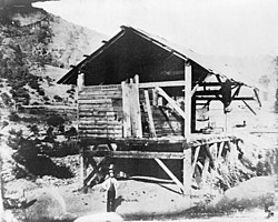
 Sutter's Mill 1850 | |
| Nearest city | Placerville, California[4] |
| Area | c. 250 acres (100 ha) |
| Built | 1848 |
| NRHP reference No. | 66000207[3] |
| Significant dates | |
| Added to NRHP | October 15, 1966[3] |
| Designated NHLD | July 4, 1961[5] |
Coloma (Nisenan: Cullumah, meaning "beautiful") is a census-designated place[6] in El Dorado County, California, US. It is approximately 36 miles (58 km) northeast of Sacramento, California. Coloma is most noted for being the site where James W. Marshall found gold in the Sierra Nevada foothills, at Sutter's Mill on January 24, 1848,[4] leading to the California Gold Rush. Coloma's population is 529.
The settlement is a tourist attraction known for its ghost town and the centerpiece of the Marshall Gold Discovery State Historic Park. Coloma was designated a National Historic Landmark District on July 4, 1961.[4][5]
It lies at an elevation of 764 feet (233 m).[2]
- ^ "2020 U.S. Gazetteer Files". United States Census Bureau. Retrieved October 30, 2021.
- ^ a b U.S. Geological Survey Geographic Names Information System: Coloma, California
- ^ a b "National Register Information System". National Register of Historic Places. National Park Service. July 9, 2010.
- ^ a b c Allen W. Welts (February 1970). "National Register of Historic Places Inventory-Nomination: Marshall Gold Discovery State Historic Park / Coloma" (PDF). National Park Service. Retrieved June 22, 2009.
{{cite journal}}: Cite journal requires|journal=(help) and Accompanying one image, from 1850s (213 KB) - ^ a b "Coloma". National Historic Landmark summary listing. National Park Service. Archived from the original on October 8, 2012. Retrieved June 29, 2008.
- ^ U.S. Geological Survey Geographic Names Information System: Coloma, California
