Columbia, Missouri | |
|---|---|
City | |
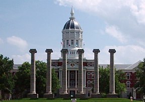
From top, left to right: Jesse Hall and The Columns at the University of Missouri, Missouri United Methodist Church, the State Historical Society of Missouri, The Big Tree, Memorial Union, Ragtag Cinema, the Boone County Courthouse | |
| Nicknames: | |
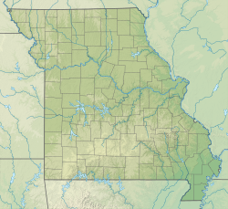
 Interactive map of Columbia | |
| Coordinates: 38°56′51″N 92°19′36″W / 38.94750°N 92.32667°W | |
| Country | United States |
| State | Missouri |
| County | Boone |
| Founded | 1821 |
| Incorporated | 1826 |
| Named for | Columbia |
| Government | |
| • Type | Council–manager |
| • Body | Columbia City Council |
| • Mayor | Barbara Buffaloe[3] |
| • City manager | De'Carlon Seewood |
| Area | |
• Total | 67.45 sq mi (174.70 km2) |
| • Land | 67.17 sq mi (173.98 km2) |
| • Water | 0.28 sq mi (0.72 km2) |
| Elevation | 761 ft (232 m) |
| Population (2020) | |
• Total | 126,254 |
• Estimate (2023) | 129,330 |
| • Rank | US: 222nd MO: 4th |
| • Density | 1,879.48/sq mi (725.67/km2) |
| • Metro | 210,864 (216th) |
| • CSA | 410,851 (102nd) |
| Demonym | Columbian |
| Time zone | UTC−6 (CST) |
| • Summer (DST) | UTC−5 (CDT) |
| ZIP Codes | 65201, 65202, 65203, 65211 |
| Area code | 573 |
| FIPS code | 29-15670 |
| GNIS feature ID | 2393605[5] |
| Website | www |
| [6][7] | |
Columbia /kəˈlʌmbiə/ is a city in the U.S. state of Missouri. It is the county seat of Boone County and home to the University of Missouri.[8] Founded in 1821, it is the principal city of the three-county Columbia metropolitan area. It is Missouri's fourth most populous with an estimated 128,555 residents in 2022.[9][10][11]
As a Midwestern college town, Columbia maintains high-quality health care facilities, cultural opportunities, and a low cost of living.[12] The tripartite establishment of Stephens College (1833), the University of Missouri (1839), and Columbia College (1851), which surround the city's Downtown to the east, south, and north, has made Columbia a center of learning. At its center is 8th Street (also known as the Avenue of the Columns), which connects Francis Quadrangle and Jesse Hall to the Boone County Courthouse and the City Hall. Originally an agricultural town, education is now Columbia's primary economic concern, with secondary interests in the healthcare, insurance, and technology sectors; it has never been a manufacturing center. Companies like Shelter Insurance, Carfax, Veterans United Home Loans, Slackers CDs and Games, and Dungarees were founded in the city. Cultural institutions include the State Historical Society of Missouri, the Museum of Art and Archaeology, and the annual True/False Film Festival and the Roots N Blues Festival. The Missouri Tigers, the state's only college athletic program which sponsors FBS football, play football at Faurot Field and basketball at Mizzou Arena as members of the rigorous Southeastern Conference.
The city rests upon the forested hills and rolling prairies of Mid-Missouri, near the Missouri River valley, where the Ozark Mountains begin to transform into plains and savanna. Limestone forms bluffs and glades while rain dissolves the bedrock, creating caves and springs which water the Hinkson, Roche Perche, and Bonne Femme creeks. Surrounding the city, Rock Bridge Memorial State Park, Mark Twain National Forest, and Big Muddy National Fish and Wildlife Refuge form a greenbelt preserving sensitive and rare environments. The Columbia Agriculture Park is home to the Columbia Farmers Market.
The first humans who entered the area at least 12,000 years ago were nomadic hunters. Later, woodland tribes lived in villages along waterways and built mounds in high places. The Osage and Missouria nations were expelled by the exploration of French traders and the rapid settlement of American pioneers. The latter arrived by the Boone's Lick Road and hailed from the culture of the Upland South, especially Virginia, Kentucky, and Tennessee. From 1812, the Boonslick area played a pivotal role in Missouri's early history and the nation's westward expansion. German, Irish, and other European immigrants soon joined. The modern populace is unusually diverse, over 8% foreign-born. White and black people are the largest ethnicities, and people of Asian descent are the third-largest group. Columbia has been known as the "Athens of Missouri" for its classic beauty and educational emphasis, but is more commonly called "CoMo".[2]
- ^ Switzler, William (1882). History of Boone County, Missouri. St. Louis Western Historical Company. pp. 220–221.
- ^ a b Alban, Sarah (October 30, 2007). "How CoMO does Halloween". The Maneater. Archived from the original on October 16, 2008. Retrieved July 18, 2008.
- ^ "City Council".
- ^ "ArcGIS REST Services Directory". United States Census Bureau. Retrieved August 28, 2022.
- ^ a b U.S. Geological Survey Geographic Names Information System: Columbia, Missouri
- ^ "About Columbia". City of Columbia, Missouri. Archived from the original on December 25, 2007. Retrieved January 1, 2008.
- ^ "City of Columbia, Missouri Demographic Statistics" (PDF). City of Columbia, Missouri. Archived from the original (PDF) on December 1, 2007. Retrieved January 1, 2008.
- ^ "Find a County". National Association of Counties. Archived from the original on May 31, 2011. Retrieved 2011-06-07.
- ^ Sauter, Michael B. (April 10, 2018). "Is your city's population keeping pace? The fastest-growing city in each state". USA Today.
- ^ "U.S. Census Bureau QuickFacts: Columbia city, Missouri". www.census.gov.
- ^ "2020 Census estimates for Missouri cities". Retrieved May 29, 2021.
- ^ "College Town, U.S.A." www.ccis.edu. Archived from the original on June 5, 2023. Retrieved November 30, 2023.


