This article needs additional citations for verification. (June 2016) |
Columbia City | |
|---|---|
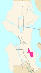
 Map of Columbia City's location in Seattle | |
| Country | United States |
| State | Washington |
| City | Seattle |
| City Council | District 2 |
| Neighborhood Council | Southeast District |
| Police District | South Precinct, R3 |
| Established [1] | Incorporated in 1893 and Annexed to Seattle in 1907 |
| Founded by | J. K. Edmiston |
| Named for | Christopher Columbus |
| Population | |
| • Total | 13,031 |
| ZIP code | 98118 |


Columbia City is a neighborhood in southeastern Seattle, Washington, within the city's Rainier Valley district. It has a landmark-protected historic business district and is one of the few Seattle neighborhoods with a long history of ethnic and income diversity.[3]
The neighborhood's main thoroughfares running north–south are Rainier Avenue S. and Martin Luther King Jr. Way S. The principal east–west thoroughfares are S. Alaska Street, S Orcas Street, and S. Genesee Street. Mass transit includes Sound Transit's Central Link light rail service from the Columbia City station (approx. 15 minutes to downtown Seattle and 20 minutes to SeaTac airport).
- ^ "Annexed Cities".
- ^ a b "King County Assessors Office - Analytics".
- ^ "Southeast Seattle ZIP Code 98118: Neighborhood of Nations". HistoryLink.org- the Free Online Encyclopedia of Washington State History. Retrieved 2016-06-12.