| Columbia Plateau ecoregion | |
|---|---|
 | |
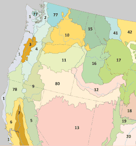
 Level III ecoregions of the Pacific Northwest. The Columbia Plateau ecoregion is marked with (10). | |
| Ecology | |
| Realm | Nearctic |
| Borders | |
| Geography | |
| Countries |
|
| States/Provinces | |
| Coordinates | 47°N 119°W / 47°N 119°W |
The Columbia Plateau ecoregion is a Level III ecoregion designated by the United States Environmental Protection Agency (EPA) encompassing approximately 32,100 square miles (83,139 km2)[1] of land within the U.S. states of Washington, Oregon, and Idaho. The ecoregion extends across a wide swath of the Columbia River Basin from The Dalles, Oregon to Lewiston, Idaho to Okanogan, Washington near the Canada–U.S. border. It includes nearly 500 miles (800 km) of the Columbia River, as well as the lower reaches of major tributaries such as the Snake and Yakima rivers and the associated drainage basins. It is named for the Columbia Plateau, a flood basalt plateau formed by the Columbia River Basalt Group during the late Miocene and early Pliocene. The arid sagebrush steppe and grasslands of the region are flanked by moister, predominantly forested, mountainous ecoregions on all sides. The underlying basalt is up to 2 miles (3 km) thick and partially covered by thick loess deposits.[2] Where precipitation amounts are sufficient, the deep loess soils have been extensively cultivated for wheat. Water from the Columbia River is subject to resource allocation debates involving fisheries, navigation, hydropower, recreation, and irrigation, and the Columbia Basin Project has dramatically converted much of the region to agricultural use.[2][3][4]
The Columbia Plateau ecoregion has been subdivided into at least fourteen Level IV ecoregions, as described below. The EPA has not yet published an Ecoregions of Washington poster similar to the informational posters for Oregon and Idaho, and the Washington information presented here is not as complete as the information about the other two states.
- ^ Final Programmatic Environmental Impact Statement on Wind Energy Development on BLM-Administered Lands in the Western United States. United States Department of the Interior; Bureau of Land Management. p. 6. Retrieved October 24, 2018.
columbia plateau 32100.
- ^ a b
 This article incorporates public domain material from Thorson, TD; Bryce, SA; Lammers, DA; et al. Ecoregions of Oregon (PDF). United States Geological Survey. (color poster with map, descriptive text, summary tables, and photographs; with a Reverse side).
- ^
 This article incorporates public domain material from McGrath, CL; Woods, AJ; Omernik, JM; et al. Ecoregions of Idaho (PDF). United States Geological Survey. (color poster with map, descriptive text, summary tables, and photographs; with a Reverse side).
- ^ U.S. Environmental Protection Agency, Draft: Level III and IV Ecoregions of the Northwestern United States (PDF), archived from the original (PDF) on 2019-04-12 Cited for Washington information instead of an Ecoregions of Washington poster, which has not yet been located.