for the pseudonymous artist, see Therese Emilie Henriette Winkel
Comala | |
|---|---|
Town & Municipality | |
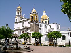
 Main plaza and church | |
| Coordinates: 19°19′15″N 103°45′37″W / 19.32083°N 103.76028°W | |
| Country | |
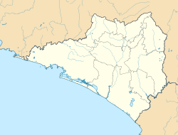
| State | Colima |
| Founded | 1550s |
| Municipal Status | 1856 |
| Government | |
| • Municipal President | Sergio Agustín Morales Anguiano |
| Area | |
| • Municipality | 254 km2 (98 sq mi) |
| Elevation (of seat) | 600 m (2,000 ft) |
| Population (2010) Municipality | |
| • Municipality | 20,888 |
| • Seat | 9,442 |
| Time zone | UTC-6 (Central (US Central)) |
| • Summer (DST) | UTC-5 (Central) |
| Postal code (of seat) | 28450 |
| Area code | 312 |
| Website | www |
Comala (Spanish: [koˈmala] ) is a town and municipality located in the Mexican state of Colima, near the state capital of Colima. It has been nicknamed the "White Village of America"[1] as the façades of the buildings in town have all been painted white since the 1960s. The historic center of the town was declared a Historic Monument Zone and the town became a Pueblo Mágico in 2002. It is the municipal seat of the Comala Municipality, the local governing authority for over 400 other communities, including the former Nogueras Hacienda, the home of artist Alejandro Rangel Hidalgo.
- ^ México, Travel By. "The Streets of Comala, Comalá". Travel By Mexico. Retrieved 2024-07-17.


