Commewijne | |
|---|---|
 | |
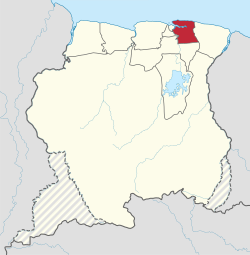
 Map of Suriname showing Commewijne district | |
| Coordinates: 5°52′N 55°04′W / 5.867°N 55.067°W | |
| Country | Suriname |
| Capital | Nieuw Amsterdam |
| Area | |
• Total | 2,353 km2 (908 sq mi) |
| Population (2012 census)[1] | |
• Total | 31,420 |
| • Density | 13/km2 (35/sq mi) |
| Time zone | UTC-3 |
Commewijne is a district of Suriname, located on the right bank of the Suriname River. Commewijne's capital city is Nieuw Amsterdam. Tamanredjo is another major town, while Meerzorg is the most populated.[1]
The district has a population of 31,420 and an area of 2,353 km2.[1]
One of the most populated of Suriname's districts, Commewijne relies primarily on agriculture for its income, with plantations dating back to the first Dutch colonisation of the area in the 17th century.[2] In the 21st century, Meerzorg has been designated as a regional centre, and suburban area for Paramaribo, and is the site of many building projects. Nieuw Amsterdam has been steadily growing as well.[3]
- ^ a b c "2012 Census Resorts Suriname" (PDF). Spang Staging. Retrieved 11 May 2020.
- ^ "Distrikt Commewijne 1". Suriname.nu (in Dutch). Retrieved 25 May 2020.
- ^ "Structuur Analyse" (PDF). Planning Office Suriname (in Dutch). Retrieved 25 May 2020.