This article lacks inline citations besides NRIS, a database which provides minimal and sometimes ambiguous information. (January 2017) |
| Como-Harriet Streetcar Line (CHSL) | ||||||||||||||||||||||||||||||||||||||||||||||||||||||||||||||||||||
|---|---|---|---|---|---|---|---|---|---|---|---|---|---|---|---|---|---|---|---|---|---|---|---|---|---|---|---|---|---|---|---|---|---|---|---|---|---|---|---|---|---|---|---|---|---|---|---|---|---|---|---|---|---|---|---|---|---|---|---|---|---|---|---|---|---|---|---|---|
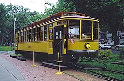
 Twin City Rapid Transit No. 1300 | ||||||||||||||||||||||||||||||||||||||||||||||||||||||||||||||||||||
| Overview | ||||||||||||||||||||||||||||||||||||||||||||||||||||||||||||||||||||
| Owner | Minnesota Streetcar Museum (cars), Minneapolis (right-of-way) | |||||||||||||||||||||||||||||||||||||||||||||||||||||||||||||||||||
| Locale | Minneapolis, Minnesota | |||||||||||||||||||||||||||||||||||||||||||||||||||||||||||||||||||
| Termini | ||||||||||||||||||||||||||||||||||||||||||||||||||||||||||||||||||||
| Stations | 1 | |||||||||||||||||||||||||||||||||||||||||||||||||||||||||||||||||||
| Service | ||||||||||||||||||||||||||||||||||||||||||||||||||||||||||||||||||||
| Type | Heritage streetcar | |||||||||||||||||||||||||||||||||||||||||||||||||||||||||||||||||||
| System | Minnesota Streetcar Museum ex-TCRT | |||||||||||||||||||||||||||||||||||||||||||||||||||||||||||||||||||
| Operator(s) | Minnesota Streetcar Museum | |||||||||||||||||||||||||||||||||||||||||||||||||||||||||||||||||||
| Rolling stock | TCRT and PCC streetcars from old TCRT system | |||||||||||||||||||||||||||||||||||||||||||||||||||||||||||||||||||
| History | ||||||||||||||||||||||||||||||||||||||||||||||||||||||||||||||||||||
| Opened | August 28, 1971 | |||||||||||||||||||||||||||||||||||||||||||||||||||||||||||||||||||
| Technical | ||||||||||||||||||||||||||||||||||||||||||||||||||||||||||||||||||||
| Character | right-of-way | |||||||||||||||||||||||||||||||||||||||||||||||||||||||||||||||||||
| Track gauge | 4 ft 8+1⁄2 in (1,435 mm) standard gauge | |||||||||||||||||||||||||||||||||||||||||||||||||||||||||||||||||||
| Electrification | Overhead lines | |||||||||||||||||||||||||||||||||||||||||||||||||||||||||||||||||||
| ||||||||||||||||||||||||||||||||||||||||||||||||||||||||||||||||||||
Como-Harriet Streetcar Line and Trolley | |
 Twin City Rapid Transit No. 1300 | |
| Location | Minneapolis, MN |
|---|---|
| Coordinates | 44°55′58.91″N 93°18′29.53″W / 44.9330306°N 93.3082028°W |
| Built | 1898 |
| Architect | Minneapolis Street Railway Co.; Twin City Rapid Transit |
| NRHP reference No. | 77000739 [1] |
| Added to NRHP | October 17, 1977 |
The Como-Harriet Streetcar Line (CHSL) is a heritage streetcar line in Minneapolis, Minnesota, which follows original streetcar right-of-way between Lake Harriet and Bde Maka Ska and is operated by the Minnesota Streetcar Museum. The heritage line was originally developed in the 1970s by the Minnesota Transportation Museum which spun off streetcar operations in the winter of 2004–2005.
- ^ "National Register Information System". National Register of Historic Places. National Park Service. January 23, 2007.