| Compton Glacier | |
|---|---|
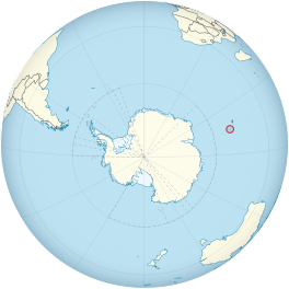
 Location of Heard Island and McDonald Islands on the globe | |
| Type | cirque / tidewater |
| Location | Heard Island Territory of Heard Island and McDonald Islands Australia |
| Coordinates | 53°3′S 73°37′E / 53.050°S 73.617°E |
| Length | 3 nautical miles (6 km) |
| Thickness | 55 meters |
| Terminus | Compton Lagoon, between Gilchrist Beach and Fairchild Beach |
| Status | Retreating[1][2][3][4][5] |
 | |
Compton Glacier is a glacier, 3 nautical miles (6 km) long, flowing northeast from the lower slopes of the Big Ben massif to the northeast side of Heard Island in the southern Indian Ocean. Its terminus is located at Compton Lagoon, between Gilchrist Beach and Fairchild Beach.[6][7] To the northwest of Compton Glacier is Ealey Glacier, whose terminus is located close southeast of Cape Bidlingmaier. To the southeast of Compton Glacier is Brown Glacier, whose terminus is located at Brown Lagoon. Round Hill separates Compton Glacier from Brown Glacier. Since the ANARE survey of 1947/48, the glacier has retreated significantly, exposing much more of Compton Lagoon.[8] Evidence for significant loss was recorded as early as 1963, with an expedition describing the glacier as no longer smooth, but crevassed.[9] By the late 1970s it had retreated 1.6 km and by the time of a 1987 survey, it was 2.5 km inland from its 1947 front.[10]
- ^ Ian F. Allison; Peter L. Keage (1986). "Recent changes in the glaciers of Heard Island". Polar Record. 23 (144): 255–272. doi:10.1017/S0032247400007099. S2CID 130086301.
- ^ Andrew Ruddell (25 May 2010). "Our subantarctic glaciers: why are they retreating?". Glaciology Program, Antarctic CRC and AAD. Archived from the original on 2 October 2009. Retrieved 5 June 2010.
- ^ Quilty, P.G.; Wheller, G. (2000). "Heard Island and the McDonald Islands: A window into the Kerguelen Plateau (Heard Island Papers)". Pap. Proc. R. Soc. Tasm. 133 (2): 1–12.
- ^ Budd, G.M. (2000). "Changes in Heard Island glaciers, king penguins and fur seals since 1947 (Heard Island Papers)". Pap. Proc. R. Soc. Tasm. 133 (2): 47–60.
- ^ Douglas E. Thost; Martin Truffer (February 2008). "Glacier Recession on Heard Island, Southern Indian Ocean". Arctic, Antarctic, and Alpine Research. 40 (1): 199–214. doi:10.1657/1523-0430(06-084)[THOST]2.0.CO;2. S2CID 130245283. Archived from the original on 4 December 2012. Retrieved 7 June 2010.
- ^ "Compton Glacier". Geographic Names Information System. United States Geological Survey, United States Department of the Interior. Retrieved 5 June 2010.
- ^ "Compton Glacier". Australian Antarctic Data Centre. Retrieved 5 June 2010.
- ^ Green, Ken (2000). "Coastal studies at Heard Island 1992/93: Changes in sea surface temperature and coastal landforms". Papers and Proceedings of the Royal Society of Tasmania. 133: 27–32. doi:10.26749/rstpp.133.2.27.
- ^ University of Illinois at Urbana-Champaign (1963). "Technical Report". 33–35. U.S. Army Natick Laboratories, Clothing & Organic Materials Division: 247.
{{cite journal}}: Cite journal requires|journal=(help) - ^ Cogley, J. Graham; Berthier, Etienne; Donoghue, Shavawn (2014). "32; Remote sensing of glaciers of the Subantarctic islands". Global Land Ice Measurements from Space. Springer Berlin Heidelberg. pp. 763–765. ISBN 9783540798187.
