| Conestoga River | |
|---|---|
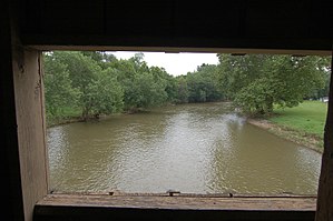
 The Conestoga River as seen from the inside of Hunsecker's Mill Covered Bridge in Lancaster County | |
 | |
| Native name | Kanneschtooge Rewwer (Pennsylvania German) |
| Physical characteristics | |
| Source | |
| • location | State Game Lands 52, Lancaster and Berks County, Pennsylvania |
| • coordinates | 40°10′47″N 75°56′32″W / 40.17972°N 75.94222°W[1] |
| • elevation | 800 ft (240 m)[2] |
| Mouth | |
• location | Susquehanna River, Safe Harbor, Lancaster County, Pennsylvania |
• coordinates | 39°55′31″N 76°23′3″W / 39.92528°N 76.38417°W |
• elevation | 170 ft (52 m)[3] |
| Length | 61.6 miles (99.1 km) |
| Basin size | 491 square miles (1,270 km2) |
| Discharge | |
| • average | 670 cubic feet per second (19 m3/s) |
| Basin features | |
| Tributaries | |
| • left | Groff Creek, Mill Creek |
| • right | Muddy Creek, Cocalico Creek, Lititz Run, Little Conestoga Creek |
The Conestoga River (Pennsylvania German: Kanneschtooge Rewwer), also referred to as Conestoga Creek (Pennsylvania German: Kanneschtooge Grick), is a 61.6-mile-long (99.1 km)[4] tributary of the Susquehanna River flowing through the center of Lancaster County, Pennsylvania, United States.
- ^ Crable, Ad. "A journey to find the source of Lancaster County's Conestoga River". LancasterOnline. LNP. Retrieved 7 May 2020.
- ^ United States Geological Survey (1999). Morgantown, PA (PDF) (Topographic map). 1:24,000. 7.5 Minute Series. Reston, VA: United States Geological Survey. Retrieved May 7, 2020.
- ^ United States Geological Survey (1995). Safe Harbor, PA (PDF) (Topographic map). 1:24,000. 7.5 Minute Series. Reston, VA: United States Geological Survey. Retrieved May 7, 2020.
- ^ U.S. Geological Survey. National Hydrography Dataset high-resolution flowline data. The National Map Archived 2016-06-30 at the Wayback Machine, accessed August 8, 2011